Pulumer geodata
Pulumer (Tunceli) is a seat of a second-order administrative division; located in Turkey in Europe/Istanbul (GMT+3) time zone. With population of 1,759 people, there are 983 cities with bigger population in this country. Compared to other cities in Turkey, 61% of cities are located further ↓South; 73.1% of cities are located further ←West and 90.6% of cities have lower elevation than Pulumer. Note1


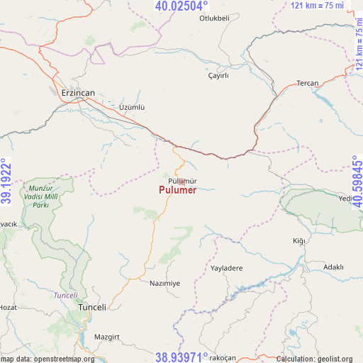
Pulumer GPS coordinates[2]
39° 29' 4.164" North, 39° 53' 43.152" East
| Map corner | latitude | longitude |
|---|---|---|
| Upper-left | 40.02504°, | 39.1922° |
| Center: | 39.48449°, | 39.89532° |
| Lower-right: | 38.93971°, | 40.59845° |
| Map W x H: | 120.7×120.7 km | = 75×75mi |
| max Lat: | 42.02683° ⇑39% North |
| Pulumer: | 39.48449° |
| min Lat: | ⇓61% South 35.9025° |
| min Long | Pulumer | max Long |
| 25.90902° | 39.89532° | 44.60099° |
| W 73.1%⇐ | ⇒26.9% E |
Elevation
Elevation of Pulumer is 1499 m = 4918 ft, and this is 781.6 m = 2564 ft above average elevation for this country.
| Max E: |
2682 m = 8799 ft | 9.4% |
| Pulumer | 1499 m 4918 ft | |
| Avg. | 717.4 m = 2354 ft | |
Min E: |
0 m = 0 ft | 90.6% |
See also: Turkey elevation on elevation.city.
Geographical zone
Pulumer is located in North temperate zone (between Tropic of Cancer and the Arctic Circle). Distance of this Northern Tropic circle is 1784.3 km =1108.7 mi to South.| Distance of | km | miles | from Pulumer |
|---|---|---|---|
| North Pole | 5616.8 | 3490.1 | to North |
| Arctic Circle | 3010.9 | 1870.9 | to North |
| Tropic Cancer | 1784.3 | 1108.7 | to South |
| Equator | 4390.3 | 2728 | to South |


Nearby cities:
15 places around Pulumer: (largest is in red/bold)
• Balpayam
15.6 km =9.7 mi,  117°
117°
• Başköy
43.4 km =27 mi,  353°
353°
• Cimin
30.1 km =18.7 mi,  326°
326°
• Dallıbahçe
39.1 km =24.3 mi,  182°
182°
• Dağyolu
6.1 km =3.8 mi,  9°
9°
• Dereova
26.1 km =16.2 mi, 184°
• Kasaba
43.5 km =27 mi, 115°
• Mezraa
12.5 km =7.8 mi,  209°
209°
• Nazimiye
34.4 km =21.4 mi,  189°
189°
• Tanyeri
15.1 km =9.4 mi,  338°
338°
• Turluk
5.1 km =3.2 mi,  197°
197°
• Yayladere
32.4 km =20.1 mi,  152°
152°
• Çayırlı
37.7 km =23.4 mi,  17°
17°
• Çağlayan
21.1 km =13.1 mi,  302°
302°
• Üçdam
25.6 km =15.9 mi,  70°
70°
Sources, notices
• [Note1] Compared only with cities in Turkey existing in our database
• [Src1] Map data: © OpenStreetMap contributors (CC-BY-SA)
• [Src2] Other city data from geonames.org with taken over terms of usage.
• [Src3] Geographical zone / Annual Mean Temperature by Robert A. Rohde @ Wikipedia
