Balpayam geodata
Balpayam (Tunceli) is a seat of a third-order administrative division; located in Turkey in Europe/Istanbul (GMT+3) time zone. In our database, there are 1323 cities with bigger population. Compared to other cities in Turkey, 60.1% of cities are located further ↓South; 73.8% of cities are located further ←West and 99.3% of cities have lower elevation than Balpayam. Note1


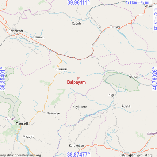
Balpayam GPS coordinates[2]
39° 25' 12.216" North, 40° 3' 25.668" East
| Map corner | latitude | longitude |
|---|---|---|
| Upper-left | 39.96111°, | 39.35401° |
| Center: | 39.42006°, | 40.05713° |
| Lower-right: | 38.87477°, | 40.76026° |
| Map W x H: | 120.8×120.8 km | = 75.1×75.1mi |
| max Lat: | 42.02683° ⇑39.9% North |
| Balpayam: | 39.42006° |
| min Lat: | ⇓60.1% South 35.9025° |
| min Long | Balpayam | max Long |
| 25.90902° | 40.05713° | 44.60099° |
| W 73.8%⇐ | ⇒26.2% E |
Elevation
Elevation of Balpayam is 2052 m = 6732 ft, and this is 1334.6 m = 4379 ft above average elevation for this country.
| Max E: |
2682 m = 8799 ft | 0.7% |
| Balpayam | 2052 m 6732 ft | |
| Avg. | 717.4 m = 2354 ft | |
Min E: |
0 m = 0 ft | 99.3% |
See also: Turkey elevation on elevation.city.
Geographical zone
Balpayam is located in North temperate zone (between Tropic of Cancer and the Arctic Circle). Distance of this Northern Tropic circle is 1777.2 km =1104.3 mi to South.| Distance of | km | miles | from Balpayam |
|---|---|---|---|
| North Pole | 5624 | 3494.6 | to North |
| Arctic Circle | 3018.1 | 1875.4 | to North |
| Tropic Cancer | 1777.2 | 1104.3 | to South |
| Equator | 4383.1 | 2723.5 | to South |


Nearby cities:
15 places around Balpayam: (largest is in red/bold)
• Adaklı
42.5 km =26.4 mi,  120°
120°
• Dallıbahçe
35.4 km =22 mi,  205°
205°
• Dağyolu
18.4 km =11.4 mi,  315°
315°
• Dereova
24.8 km =15.4 mi,  220°
220°
• Kasaba
27.8 km =17.3 mi, 115°
• Mezraa
20.4 km =12.7 mi,  259°
259°
• Nazimiye
33.2 km =20.6 mi, 216°
• Pulumer
15.6 km =9.7 mi,  297°
297°
• Tanyeri
28.8 km =17.9 mi, 317°
• Turluk
15.6 km =9.7 mi,  278°
278°
• Yayladere
21.6 km =13.4 mi,  177°
177°
• Yedisu
41 km =25.5 mi,  88°
88°
• Çan
32.7 km =20.3 mi,  157°
157°
• Çağlayan
36.7 km =22.8 mi, 300°
• Üçdam
18.9 km =11.7 mi,  32°
32°
Sources, notices
• [Note1] Compared only with cities in Turkey existing in our database
• [Src1] Map data: © OpenStreetMap contributors (CC-BY-SA)
• [Src2] Other city data from geonames.org with taken over terms of usage.
• [Src3] Geographical zone / Annual Mean Temperature by Robert A. Rohde @ Wikipedia
