Çan geodata
Çan (Elazığ) is a seat of a second-order administrative division; located in Turkey in Europe/Istanbul (GMT+3) time zone. In our database, there are 1323 cities with bigger population. Compared to other cities in Turkey, 56.7% of cities are located further ↓South; 74.9% of cities are located further ←West and 87.6% of cities have lower elevation than Çan. Note1


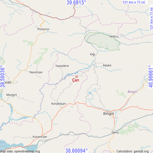
Çan GPS coordinates[2]
39° 8' 53.988" North, 40° 12' 12.528" East
| Map corner | latitude | longitude |
|---|---|---|
| Upper-left | 39.6915°, | 39.50036° |
| Center: | 39.14833°, | 40.20348° |
| Lower-right: | 38.60094°, | 40.90661° |
| Map W x H: | 121.3×121.3 km | = 75.4×75.4mi |
| max Lat: | 42.02683° ⇑43.3% North |
| Çan: | 39.14833° |
| min Lat: | ⇓56.7% South 35.9025° |
| min Long | Çan | max Long |
| 25.90902° | 40.20348° | 44.60099° |
| W 74.9%⇐ | ⇒25.1% E |
Elevation
Elevation of Çan is 1388 m = 4554 ft, and this is 670.6 m = 2200 ft above average elevation for this country.
| Max E: |
2682 m = 8799 ft | 12.4% |
| Çan | 1388 m 4554 ft | |
| Avg. | 717.4 m = 2354 ft | |
Min E: |
0 m = 0 ft | 87.6% |
See also: Turkey elevation on elevation.city.
Geographical zone
Çan is located in North temperate zone (between Tropic of Cancer and the Arctic Circle). Distance of this Northern Tropic circle is 1747 km =1085.5 mi to South.| Distance of | km | miles | from Çan |
|---|---|---|---|
| North Pole | 5654.2 | 3513.4 | to North |
| Arctic Circle | 3048.3 | 1894.1 | to North |
| Tropic Cancer | 1747 | 1085.5 | to South |
| Equator | 4352.9 | 2704.8 | to South |


Nearby cities:
15 places around Çan: (largest is in red/bold)
• Adaklı
25.6 km =15.9 mi,  70°
70°
• Balpayam
32.7 km =20.3 mi,  337°
337°
• Başyurt
39.9 km =24.8 mi,  209°
209°
• Bingöl
38.6 km =24 mi,  139°
139°
• Dallıbahçe
28 km =17.4 mi,  266°
266°
• Darıkent
39.9 km =24.8 mi,  238°
238°
• Dereova
31 km =19.3 mi,  291°
291°
• Karakoçan
26.6 km =16.5 mi, 214°
• Kasaba
22.3 km =13.9 mi,  34°
34°
• Mezraa
42 km =26.1 mi,  308°
308°
• Nazimiye
32.5 km =20.2 mi,  276°
276°
• Sancak
17.1 km =10.6 mi,  111°
111°
• Turluk
42.9 km =26.7 mi,  319°
319°
• Yayladere
14.4 km =8.9 mi, 306°
• Yedisu
42.5 km =26.4 mi,  41°
41°
Sources, notices
• [Note1] Compared only with cities in Turkey existing in our database
• [Src1] Map data: © OpenStreetMap contributors (CC-BY-SA)
• [Src2] Other city data from geonames.org with taken over terms of usage.
• [Src3] Geographical zone / Annual Mean Temperature by Robert A. Rohde @ Wikipedia
