Yanarsu geodata
Yanarsu (Siirt) is a seat of a third-order administrative division; located in Turkey in Europe/Istanbul (GMT+3) time zone. In our database, there are 1323 cities with bigger population. Compared to other cities in Turkey, 60.8% of cities are located further ↑North; 86.7% of cities are located further ←West and 55.2% of cities have lower elevation than Yanarsu. Note1


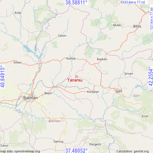
Yanarsu GPS coordinates[2]
38° 2' 11.076" North, 41° 33' 8.172" East
| Map corner | latitude | longitude |
|---|---|---|
| Upper-left | 38.58811°, | 40.84915° |
| Center: | 38.03641°, | 41.55227° |
| Lower-right: | 37.48052°, | 42.2554° |
| Map W x H: | 123.2×123.2 km | = 76.6×76.6mi |
| max Lat: | 42.02683° ⇑60.8% North |
| Yanarsu: | 38.03641° |
| min Lat: | ⇓39.2% South 35.9025° |
| min Long | Yanarsu | max Long |
| 25.90902° | 41.55227° | 44.60099° |
| W 86.7%⇐ | ⇒13.3% E |
Elevation
Elevation of Yanarsu is 791 m = 2595 ft, and this is 73.6 m = 241 ft above average elevation for this country.
| Max E: |
2682 m = 8799 ft | 44.8% |
| Yanarsu | 791 m 2595 ft | |
| Avg. | 717.4 m = 2354 ft | |
Min E: |
0 m = 0 ft | 55.2% |
See also: Turkey elevation on elevation.city.
Geographical zone
Yanarsu is located in North temperate zone (between Tropic of Cancer and the Arctic Circle). Distance of this Northern Tropic circle is 1623.3 km =1008.7 mi to South.| Distance of | km | miles | from Yanarsu |
|---|---|---|---|
| North Pole | 5777.8 | 3590.2 | to North |
| Arctic Circle | 3171.9 | 1970.9 | to North |
| Tropic Cancer | 1623.3 | 1008.7 | to South |
| Equator | 4229.3 | 2628 | to South |


Nearby cities:
15 places around Yanarsu: (largest is in red/bold)
• Asmadere
21.4 km =13.3 mi,  229°
229°
• Aviski
21 km =13 mi,  247°
247°
• Beykent
20.7 km =12.9 mi,  145°
145°
• Beyçayırı
20.2 km =12.6 mi,  262°
262°
• Beşpınar
22.6 km =14 mi,  168°
168°
• Erdurağı
15.2 km =9.4 mi, 171°
• Gökdoğan
15.9 km =9.9 mi, 234°
• Gözpınar
10.6 km =6.6 mi, 231°
• Kayabağlar
11.6 km =7.2 mi,  119°
119°
• Konakpınar
14.3 km =8.9 mi, 150°
• Kozluk
18.4 km =11.4 mi,  339°
339°
• Kurtalan
17 km =10.6 mi,  136°
136°
• Melefan
16.1 km =10 mi,  5°
5°
• Saipbeyli
5.7 km =3.5 mi,  220°
220°
• Taliban
13.6 km =8.5 mi,  243°
243°
Sources, notices
• [Note1] Compared only with cities in Turkey existing in our database
• [Src1] Map data: © OpenStreetMap contributors (CC-BY-SA)
• [Src2] Other city data from geonames.org with taken over terms of usage.
• [Src3] Geographical zone / Annual Mean Temperature by Robert A. Rohde @ Wikipedia
