Beykent geodata
Beykent (Siirt) is a populated place; located in Turkey in Europe/Istanbul (GMT+3) time zone. With population of 580 people, there are 1265 cities with bigger population in this country. Compared to other cities in Turkey, 65.9% of cities are located further ↑North; 87.5% of cities are located further ←West and 74.5% of cities have lower elevation than Beykent. Note1


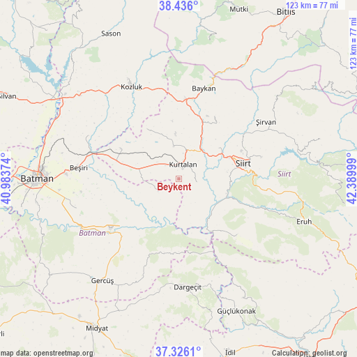
Beykent GPS coordinates[2]
37° 52' 59.304" North, 41° 41' 12.696" East
| Map corner | latitude | longitude |
|---|---|---|
| Upper-left | 38.436°, | 40.98374° |
| Center: | 37.88314°, | 41.68686° |
| Lower-right: | 37.3261°, | 42.38999° |
| Map W x H: | 123.4×123.4 km | = 76.7×76.7mi |
| max Lat: | 42.02683° ⇑65.9% North |
| Beykent: | 37.88314° |
| min Lat: | ⇓34.1% South 35.9025° |
| min Long | Beykent | max Long |
| 25.90902° | 41.68686° | 44.60099° |
| W 87.5%⇐ | ⇒12.5% E |
Elevation
Elevation of Beykent is 1098 m = 3602 ft, and this is 380.6 m = 1249 ft above average elevation for this country.
| Max E: |
2682 m = 8799 ft | 25.5% |
| Beykent | 1098 m 3602 ft | |
| Avg. | 717.4 m = 2354 ft | |
Min E: |
0 m = 0 ft | 74.5% |
See also: Turkey elevation on elevation.city.
Geographical zone
Beykent is located in North temperate zone (between Tropic of Cancer and the Arctic Circle). Distance of this Northern Tropic circle is 1606.3 km =998.1 mi to South.| Distance of | km | miles | from Beykent |
|---|---|---|---|
| North Pole | 5794.9 | 3600.8 | to North |
| Arctic Circle | 3189 | 1981.6 | to North |
| Tropic Cancer | 1606.3 | 998.1 | to South |
| Equator | 4212.2 | 2617.3 | to South |


Nearby cities:
15 places around Beykent: (largest is in red/bold)
• Aktaş
13.1 km =8.1 mi,  53°
53°
• Bağlıca
5.8 km =3.6 mi,  104°
104°
• Beşpınar
9 km =5.6 mi,  235°
235°
• Civankan
16.9 km =10.5 mi,  82°
82°
• Dilektepe
24.6 km =15.3 mi,  29°
29°
• Doluharman
23.1 km =14.4 mi,  60°
60°
• Erdurağı
9.9 km =6.2 mi,  281°
281°
• Gökdoğan
25.9 km =16.1 mi,  287°
287°
• Gözpınar
22.7 km =14.1 mi,  297°
297°
• Kayabağlar
11.6 km =7.2 mi,  351°
351°
• Konakpınar
6.6 km =4.1 mi,  313°
313°
• Kurtalan
4.7 km =2.9 mi,  357°
357°
• Saipbeyli
20 km =12.4 mi, 309°
• Siirt
22.9 km =14.2 mi, 77°
• Yanarsu
20.7 km =12.9 mi,  325°
325°
Sources, notices
• [Note1] Compared only with cities in Turkey existing in our database
• [Src1] Map data: © OpenStreetMap contributors (CC-BY-SA)
• [Src2] Other city data from geonames.org with taken over terms of usage.
• [Src3] Geographical zone / Annual Mean Temperature by Robert A. Rohde @ Wikipedia
