Kozluk geodata
Kozluk (Batman) is a seat of a second-order administrative division; located in Turkey in Europe/Istanbul (GMT+3) time zone. With population of 29,502 people, there are 255 cities with bigger population in this country. Compared to other cities in Turkey, 58.2% of cities are located further ↑North; 85.9% of cities are located further ←West and 63.6% of cities have lower elevation than Kozluk. Note1


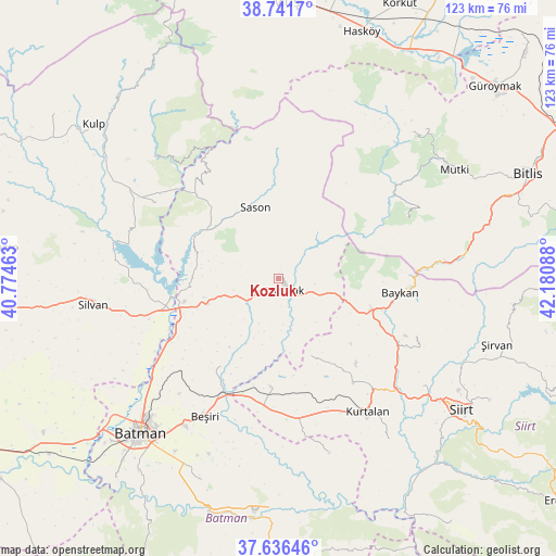
Kozluk GPS coordinates[2]
38° 11' 28.248" North, 41° 28' 39.9" East
| Map corner | latitude | longitude |
|---|---|---|
| Upper-left | 38.7417°, | 40.77463° |
| Center: | 38.19118°, | 41.47775° |
| Lower-right: | 37.63646°, | 42.18088° |
| Map W x H: | 122.9×122.9 km | = 76.4×76.4mi |
| max Lat: | 42.02683° ⇑58.2% North |
| Kozluk: | 38.19118° |
| min Lat: | ⇓41.8% South 35.9025° |
| min Long | Kozluk | max Long |
| 25.90902° | 41.47775° | 44.60099° |
| W 85.9%⇐ | ⇒14.1% E |
Elevation
Elevation of Kozluk is 937 m = 3074 ft, and this is 219.6 m = 720 ft above average elevation for this country.
| Max E: |
2682 m = 8799 ft | 36.4% |
| Kozluk | 937 m 3074 ft | |
| Avg. | 717.4 m = 2354 ft | |
Min E: |
0 m = 0 ft | 63.6% |
See also: Turkey elevation on elevation.city.
Geographical zone
Kozluk is located in North temperate zone (between Tropic of Cancer and the Arctic Circle). Distance of this Northern Tropic circle is 1640.5 km =1019.4 mi to South.| Distance of | km | miles | from Kozluk |
|---|---|---|---|
| North Pole | 5760.6 | 3579.5 | to North |
| Arctic Circle | 3154.7 | 1960.2 | to North |
| Tropic Cancer | 1640.5 | 1019.4 | to South |
| Equator | 4246.5 | 2638.7 | to South |


Nearby cities:
15 places around Kozluk: (largest is in red/bold)
• Aviski
28.3 km =17.6 mi,  206°
206°
• Baykan
26.1 km =16.2 mi,  98°
98°
• Bekirhan
17.1 km =10.6 mi,  250°
250°
• Beyçayırı
23.9 km =14.9 mi, 214°
• Gökdoğan
27.2 km =16.9 mi,  193°
193°
• Gözpınar
23.9 km =14.9 mi,  184°
184°
• Kayabağlar
28.2 km =17.5 mi,  143°
143°
• Malabadi
24.5 km =15.2 mi,  259°
259°
• Melefan
8 km =5 mi, 98°
• Meydan
31.4 km =19.5 mi,  54°
54°
• Saipbeyli
21.7 km =13.5 mi,  172°
172°
• Sason
16.2 km =10.1 mi,  339°
339°
• Taliban
24 km =14.9 mi, 193°
• Yanarsu
18.4 km =11.4 mi,  159°
159°
• Yücebağ
29.1 km =18.1 mi,  320°
320°
Sources, notices
• [Note1] Compared only with cities in Turkey existing in our database
• [Src1] Map data: © OpenStreetMap contributors (CC-BY-SA)
• [Src2] Other city data from geonames.org with taken over terms of usage.
• [Src3] Geographical zone / Annual Mean Temperature by Robert A. Rohde @ Wikipedia
