Arsuz geodata
Arsuz (Hatay) is a seat of a second-order administrative division; located in Turkey in Europe/Istanbul (GMT+3) time zone. In our database, there are 1323 cities with bigger population. Compared to other cities in Turkey, 97.2% of cities are located further ↑North; 50.3% of cities are located further →East and 99.1% of cities have higher elevation than Arsuz. Note1


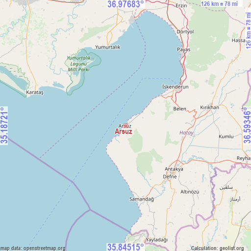
Arsuz GPS coordinates[2]
36° 24' 46.98" North, 35° 53' 25.188" East
| Map corner | latitude | longitude |
|---|---|---|
| Upper-left | 36.97683°, | 35.18721° |
| Center: | 36.41305°, | 35.89033° |
| Lower-right: | 35.84515°, | 36.59346° |
| Map W x H: | 125.8×125.8 km | = 78.2×78.2mi |
| max Lat: | 42.02683° ⇑97.2% North |
| Arsuz: | 36.41305° |
| min Lat: | ⇓2.8% South 35.9025° |
| min Long | Arsuz | max Long |
| 25.90902° | 35.89033° | 44.60099° |
| W 49.7%⇐ | ⇒50.3% E |
Elevation
Elevation of Arsuz is 6 m = 20 ft, and this is 711.4 m = 2334 ft below average elevation for this country.
| Max E: |
2682 m = 8799 ft | 99.1% |
| Avg. | 717.4 m = 2354 ft | |
| Arsuz | 6 m = 20 ft | |
Min E: |
0 m = 0 ft | 0.9% |
See also: Turkey elevation on elevation.city.
Geographical zone
Arsuz is located in North temperate zone (between Tropic of Cancer and the Arctic Circle). Distance of this Northern Tropic circle is 1442.8 km =896.5 mi to South.| Distance of | km | miles | from Arsuz |
|---|---|---|---|
| North Pole | 5958.3 | 3702.3 | to North |
| Arctic Circle | 3352.4 | 2083.1 | to North |
| Tropic Cancer | 1442.8 | 896.5 | to South |
| Equator | 4048.8 | 2515.8 | to South |


Nearby cities:
15 places around Arsuz: (largest is in red/bold)
• Anayazı
28.8 km =17.9 mi,  110°
110°
• Antakya
33.2 km =20.6 mi,  133°
133°
• Belen
28.5 km =17.7 mi,  72°
72°
• Büyük Dalyan
31.7 km =19.7 mi,  115°
115°
• Doğanköy
28 km =17.4 mi,  135°
135°
• Güneysöğüt
33.2 km =20.6 mi, 143°
• Günyazı
28.5 km =17.7 mi, 134°
• Hıdırbey
31.2 km =19.4 mi, 136°
• Kuzeytepe
28.7 km =17.8 mi, 124°
• Serinyol
29.5 km =18.3 mi,  101°
101°
• Toygarlı
27.6 km =17.1 mi, 143°
• Uzunbağ
33 km =20.5 mi,  156°
156°
• Çanakoluk
31.1 km =19.3 mi,  151°
151°
• Çırtıman
28.9 km =18 mi,  64°
64°
• İskenderun
31.9 km =19.8 mi,  52°
52°
Sources, notices
• [Note1] Compared only with cities in Turkey existing in our database
• [Src1] Map data: © OpenStreetMap contributors (CC-BY-SA)
• [Src2] Other city data from geonames.org with taken over terms of usage.
• [Src3] Geographical zone / Annual Mean Temperature by Robert A. Rohde @ Wikipedia
