Anayazı geodata
Anayazı (Hatay) is a populated place; located in Turkey in Europe/Istanbul (GMT+3) time zone. With population of 2,365 people, there are 912 cities with bigger population in this country. Compared to other cities in Turkey, 97.8% of cities are located further ↑North; 52.1% of cities are located further ←West and 78.2% of cities have higher elevation than Anayazı. Note1


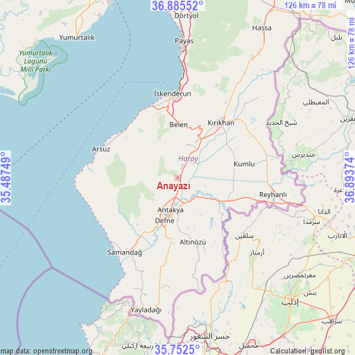
Anayazı GPS coordinates[2]
36° 19' 15.852" North, 36° 11' 26.196" East
| Map corner | latitude | longitude |
|---|---|---|
| Upper-left | 36.88552°, | 35.48749° |
| Center: | 36.32107°, | 36.19061° |
| Lower-right: | 35.7525°, | 36.89374° |
| Map W x H: | 126×126 km | = 78.3×78.3mi |
| max Lat: | 42.02683° ⇑97.8% North |
| Anayazı: | 36.32107° |
| min Lat: | ⇓2.2% South 35.9025° |
| min Long | Anayazı | max Long |
| 25.90902° | 36.19061° | 44.60099° |
| W 52.1%⇐ | ⇒47.9% E |
Elevation
Elevation of Anayazı is 135 m = 443 ft, and this is 582.4 m = 1911 ft below average elevation for this country.
| Max E: |
2682 m = 8799 ft | 78.2% |
| Avg. | 717.4 m = 2354 ft | |
| Anayazı | 135 m = 443 ft | |
Min E: |
0 m = 0 ft | 21.8% |
See also: Turkey elevation on elevation.city.
Geographical zone
Anayazı is located in North temperate zone (between Tropic of Cancer and the Arctic Circle). Distance of this Northern Tropic circle is 1432.6 km =890.2 mi to South.| Distance of | km | miles | from Anayazı |
|---|---|---|---|
| North Pole | 5968.5 | 3708.7 | to North |
| Arctic Circle | 3362.6 | 2089.4 | to North |
| Tropic Cancer | 1432.6 | 890.2 | to South |
| Equator | 4038.5 | 2509.4 | to South |


Nearby cities:
15 places around Anayazı: (largest is in red/bold)
• Antakya
13.1 km =8.1 mi,  193°
193°
• Atayurdu
17.5 km =10.9 mi,  152°
152°
• Açıkdere
12.9 km =8 mi, 151°
• Aşağıokçular
16.5 km =10.3 mi,  195°
195°
• Büyük Dalyan
4 km =2.5 mi,  155°
155°
• Doğanköy
12.2 km =7.6 mi,  216°
216°
• Dursunlu
17.3 km =10.7 mi, 189°
• Günyazı
11.8 km =7.3 mi,  213°
213°
• Hıdırbey
13.8 km =8.6 mi, 204°
• Kastal
9.3 km =5.8 mi, 151°
• Kuzeytepe
7.1 km =4.4 mi, 208°
• Mansurlu
11.7 km =7.3 mi, 162°
• Serinyol
4.9 km =3 mi,  24°
24°
• Toygarlı
16 km =9.9 mi, 221°
• Yeşilova
8.1 km =5 mi,  135°
135°
Sources, notices
• [Note1] Compared only with cities in Turkey existing in our database
• [Src1] Map data: © OpenStreetMap contributors (CC-BY-SA)
• [Src2] Other city data from geonames.org with taken over terms of usage.
• [Src3] Geographical zone / Annual Mean Temperature by Robert A. Rohde @ Wikipedia
