Serinyol geodata
Serinyol (Hatay) is a seat of a third-order administrative division; located in Turkey in Europe/Istanbul (GMT+3) time zone. With population of 16,753 people, there are 369 cities with bigger population in this country. Compared to other cities in Turkey, 97.5% of cities are located further ↑North; 52.4% of cities are located further ←West and 79% of cities have higher elevation than Serinyol. Note1


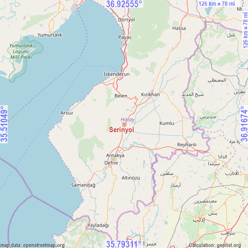
Serinyol GPS coordinates[2]
36° 21' 41.004" North, 36° 12' 48.996" East
| Map corner | latitude | longitude |
|---|---|---|
| Upper-left | 36.92555°, | 35.51049° |
| Center: | 36.36139°, | 36.21361° |
| Lower-right: | 35.79311°, | 36.91674° |
| Map W x H: | 125.9×125.9 km | = 78.2×78.2mi |
| max Lat: | 42.02683° ⇑97.5% North |
| Serinyol: | 36.36139° |
| min Lat: | ⇓2.5% South 35.9025° |
| min Long | Serinyol | max Long |
| 25.90902° | 36.21361° | 44.60099° |
| W 52.4%⇐ | ⇒47.6% E |
Elevation
Elevation of Serinyol is 122 m = 400 ft, and this is 595.4 m = 1953 ft below average elevation for this country.
| Max E: |
2682 m = 8799 ft | 79% |
| Avg. | 717.4 m = 2354 ft | |
| Serinyol | 122 m = 400 ft | |
Min E: |
0 m = 0 ft | 21% |
See also: Turkey elevation on elevation.city.
Geographical zone
Serinyol is located in North temperate zone (between Tropic of Cancer and the Arctic Circle). Distance of this Northern Tropic circle is 1437.1 km =893 mi to South.| Distance of | km | miles | from Serinyol |
|---|---|---|---|
| North Pole | 5964.1 | 3705.9 | to North |
| Arctic Circle | 3358.2 | 2086.7 | to North |
| Tropic Cancer | 1437.1 | 893 | to South |
| Equator | 4043 | 2512.2 | to South |


Nearby cities:
15 places around Serinyol: (largest is in red/bold)
• Anayazı
4.9 km =3 mi,  204°
204°
• Antakya
17.9 km =11.1 mi, 196°
• Açıkdere
16.4 km =10.2 mi,  165°
165°
• Belen
14.2 km =8.8 mi,  353°
353°
• Büyük Dalyan
8.1 km =5 mi,  182°
182°
• Doğanköy
17.1 km =10.6 mi,  213°
213°
• Günyazı
16.7 km =10.4 mi, 211°
• Hıdırbey
18.7 km =11.6 mi, 204°
• Karasüleymanlı
18.1 km =11.2 mi,  96°
96°
• Kastal
12.9 km =8 mi, 169°
• Kuzeytepe
12 km =7.5 mi, 206°
• Mansurlu
15.7 km =9.8 mi, 174°
• Uzunkavak
18.5 km =11.5 mi,  93°
93°
• Yeşilova
10.9 km =6.8 mi,  160°
160°
• Çırtıman
18.5 km =11.5 mi, 350°
Sources, notices
• [Note1] Compared only with cities in Turkey existing in our database
• [Src1] Map data: © OpenStreetMap contributors (CC-BY-SA)
• [Src2] Other city data from geonames.org with taken over terms of usage.
• [Src3] Geographical zone / Annual Mean Temperature by Robert A. Rohde @ Wikipedia
