Turgut geodata
Turgut (Konya) is a seat of a third-order administrative division; located in Turkey in Europe/Istanbul (GMT+3) time zone. In our database, there are 1323 cities with bigger population. Compared to other cities in Turkey, 51.2% of cities are located further ↑North; 67.5% of cities are located further →East and 68.2% of cities have lower elevation than Turgut. Note1


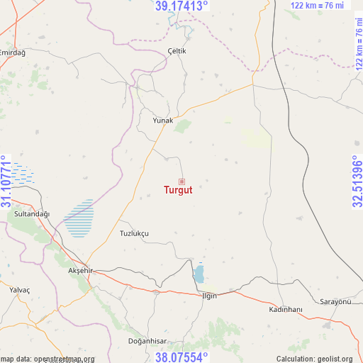
Turgut GPS coordinates[2]
38° 37' 36.984" North, 31° 48' 38.988" East
| Map corner | latitude | longitude |
|---|---|---|
| Upper-left | 39.17413°, | 31.10771° |
| Center: | 38.62694°, | 31.81083° |
| Lower-right: | 38.07554°, | 32.51396° |
| Map W x H: | 122.2×122.2 km | = 75.9×75.9mi |
| max Lat: | 42.02683° ⇑51.2% North |
| Turgut: | 38.62694° |
| min Lat: | ⇓48.8% South 35.9025° |
| min Long | Turgut | max Long |
| 25.90902° | 31.81083° | 44.60099° |
| W 32.5%⇐ | ⇒67.5% E |
Elevation
Elevation of Turgut is 1004 m = 3294 ft, and this is 286.6 m = 940 ft above average elevation for this country.
| Max E: |
2682 m = 8799 ft | 31.8% |
| Turgut | 1004 m 3294 ft | |
| Avg. | 717.4 m = 2354 ft | |
Min E: |
0 m = 0 ft | 68.2% |
See also: Turkey elevation on elevation.city.
Geographical zone
Turgut is located in North temperate zone (between Tropic of Cancer and the Arctic Circle). Distance of this Northern Tropic circle is 1689 km =1049.5 mi to South.| Distance of | km | miles | from Turgut |
|---|---|---|---|
| North Pole | 5712.1 | 3549.3 | to North |
| Arctic Circle | 3106.3 | 1930.2 | to North |
| Tropic Cancer | 1689 | 1049.5 | to South |
| Equator | 4294.9 | 2668.7 | to South |


Nearby cities:
15 places around Turgut: (largest is in red/bold)
• Akşehir
45.6 km =28.3 mi,  228°
228°
• Argıthanı
38.1 km =23.7 mi,  192°
192°
• Aşağıçiğil
64.1 km =39.8 mi,  175°
175°
• Davulga
54.6 km =33.9 mi,  315°
315°
• Doğanhisar
54.7 km =34 mi, 192°
• Ilgın
39.7 km =24.7 mi,  166°
166°
• Kadınhanı
55.4 km =34.4 mi,  140°
140°
• Kurthasanlı
46.1 km =28.6 mi, 136°
• Kuyulusebil
62.5 km =38.8 mi,  87°
87°
• Reis
44.7 km =27.8 mi,  207°
207°
• Sultandağı
51.8 km =32.2 mi,  258°
258°
• Sülüklü
54.1 km =33.6 mi,  58°
58°
• Tuzlukçu
23.1 km =14.4 mi,  224°
224°
• Yunak
21.9 km =13.6 mi,  341°
341°
• Çeltik
44.2 km =27.5 mi,  357°
357°
Sources, notices
• [Note1] Compared only with cities in Turkey existing in our database
• [Src1] Map data: © OpenStreetMap contributors (CC-BY-SA)
• [Src2] Other city data from geonames.org with taken over terms of usage.
• [Src3] Geographical zone / Annual Mean Temperature by Robert A. Rohde @ Wikipedia
