Kadınhanı geodata
Kadınhanı (Konya) is a seat of a second-order administrative division; located in Turkey in Europe/Istanbul (GMT+3) time zone. With population of 15,301 people, there are 387 cities with bigger population in this country. Compared to other cities in Turkey, 57.4% of cities are located further ↑North; 65.6% of cities are located further →East and 75.9% of cities have lower elevation than Kadınhanı. Note1


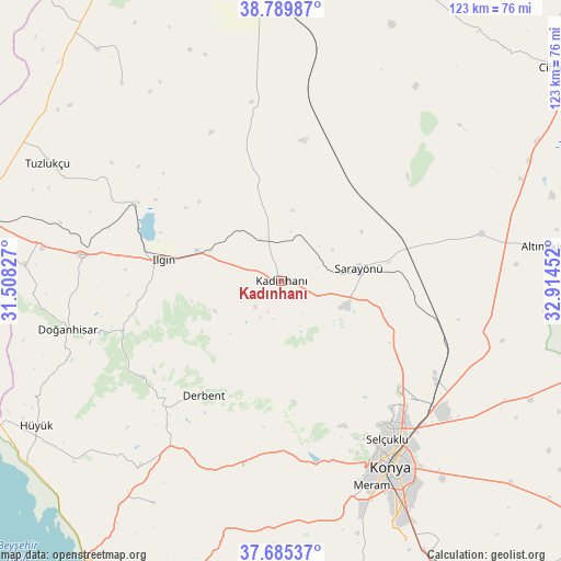
Kadınhanı GPS coordinates[2]
38° 14' 22.992" North, 32° 12' 41.004" East
| Map corner | latitude | longitude |
|---|---|---|
| Upper-left | 38.78987°, | 31.50827° |
| Center: | 38.23972°, | 32.21139° |
| Lower-right: | 37.68537°, | 32.91452° |
| Map W x H: | 122.8×122.8 km | = 76.3×76.3mi |
| max Lat: | 42.02683° ⇑57.4% North |
| Kadınhanı: | 38.23972° |
| min Lat: | ⇓42.6% South 35.9025° |
| min Long | Kadınhanı | max Long |
| 25.90902° | 32.21139° | 44.60099° |
| W 34.4%⇐ | ⇒65.6% E |
Elevation
Elevation of Kadınhanı is 1121 m = 3678 ft, and this is 403.6 m = 1324 ft above average elevation for this country.
| Max E: |
2682 m = 8799 ft | 24.1% |
| Kadınhanı | 1121 m 3678 ft | |
| Avg. | 717.4 m = 2354 ft | |
Min E: |
0 m = 0 ft | 75.9% |
See also: Turkey elevation on elevation.city.
Geographical zone
Kadınhanı is located in North temperate zone (between Tropic of Cancer and the Arctic Circle). Distance of this Northern Tropic circle is 1645.9 km =1022.7 mi to South.| Distance of | km | miles | from Kadınhanı |
|---|---|---|---|
| North Pole | 5755.2 | 3576.1 | to North |
| Arctic Circle | 3149.3 | 1956.9 | to North |
| Tropic Cancer | 1645.9 | 1022.7 | to South |
| Equator | 4251.9 | 2642 | to South |


Nearby cities:
15 places around Kadınhanı: (largest is in red/bold)
• Argıthanı
43.8 km =27.2 mi,  277°
277°
• Aşağıpınarbaşı
40.8 km =25.4 mi,  123°
123°
• Aşağıçiğil
36.9 km =22.9 mi,  235°
235°
• Derbent
30.3 km =18.8 mi,  214°
214°
• Doğanhisar
47.9 km =29.8 mi,  257°
257°
• Ilgın
26.3 km =16.3 mi, 279°
• Karatay
49.9 km =31 mi,  146°
146°
• Konya
47.4 km =29.5 mi, 149°
• Kurthasanlı
10.1 km =6.3 mi,  341°
341°
• Kuyulusebil
53.8 km =33.4 mi,  31°
31°
• Kızılören
42.1 km =26.2 mi,  191°
191°
• Meram
50.8 km =31.6 mi, 153°
• Sarayönü
17 km =10.6 mi,  81°
81°
• Selçuklu
46.6 km =29 mi, 148°
• Sille
39.2 km =24.4 mi, 152°
Sources, notices
• [Note1] Compared only with cities in Turkey existing in our database
• [Src1] Map data: © OpenStreetMap contributors (CC-BY-SA)
• [Src2] Other city data from geonames.org with taken over terms of usage.
• [Src3] Geographical zone / Annual Mean Temperature by Robert A. Rohde @ Wikipedia
