Ilgın geodata
Ilgın (Konya) is a seat of a second-order administrative division; located in Turkey in Europe/Istanbul (GMT+3) time zone. With population of 27,423 people, there are 269 cities with bigger population in this country. Compared to other cities in Turkey, 56.5% of cities are located further ↑North; 67% of cities are located further →East and 70.6% of cities have lower elevation than Ilgın. Note1


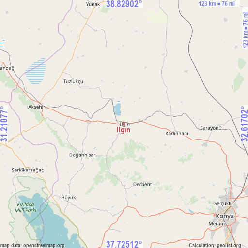
Ilgın GPS coordinates[2]
38° 16' 45.012" North, 31° 54' 50.004" East
| Map corner | latitude | longitude |
|---|---|---|
| Upper-left | 38.82902°, | 31.21077° |
| Center: | 38.27917°, | 31.91389° |
| Lower-right: | 37.72512°, | 32.61702° |
| Map W x H: | 122.7×122.7 km | = 76.2×76.2mi |
| max Lat: | 42.02683° ⇑56.5% North |
| Ilgın: | 38.27917° |
| min Lat: | ⇓43.5% South 35.9025° |
| min Long | Ilgın | max Long |
| 25.90902° | 31.91389° | 44.60099° |
| W 33%⇐ | ⇒67% E |
Elevation
Elevation of Ilgın is 1036 m = 3399 ft, and this is 318.6 m = 1045 ft above average elevation for this country.
| Max E: |
2682 m = 8799 ft | 29.4% |
| Ilgın | 1036 m 3399 ft | |
| Avg. | 717.4 m = 2354 ft | |
Min E: |
0 m = 0 ft | 70.6% |
See also: Turkey elevation on elevation.city.
Geographical zone
Ilgın is located in North temperate zone (between Tropic of Cancer and the Arctic Circle). Distance of this Northern Tropic circle is 1650.3 km =1025.4 mi to South.| Distance of | km | miles | from Ilgın |
|---|---|---|---|
| North Pole | 5750.8 | 3573.4 | to North |
| Arctic Circle | 3144.9 | 1954.1 | to North |
| Tropic Cancer | 1650.3 | 1025.4 | to South |
| Equator | 4256.2 | 2644.7 | to South |


Nearby cities:
15 places around Ilgın: (largest is in red/bold)
• Akşehir
44.3 km =27.5 mi,  281°
281°
• Argıthanı
17.5 km =10.9 mi,  274°
274°
• Aşağıçiğil
25.7 km =16 mi,  189°
189°
• Derbent
30.8 km =19.1 mi,  163°
163°
• Doğanbey
53.3 km =33.1 mi,  182°
182°
• Doğanhisar
25.5 km =15.8 mi,  234°
234°
• Hüyük
45.6 km =28.3 mi,  217°
217°
• Kadınhanı
26.3 km =16.3 mi,  99°
99°
• Kurthasanlı
23.4 km =14.5 mi,  77°
77°
• Kızılören
49 km =30.4 mi, 158°
• Reis
29.9 km =18.6 mi, 268°
• Sarayönü
42.9 km =26.7 mi,  92°
92°
• Turgut
39.7 km =24.7 mi,  346°
346°
• Tuzlukçu
33.4 km =20.8 mi,  311°
311°
• Şarkîkaraağaç
52.8 km =32.8 mi,  245°
245°
Sources, notices
• [Note1] Compared only with cities in Turkey existing in our database
• [Src1] Map data: © OpenStreetMap contributors (CC-BY-SA)
• [Src2] Other city data from geonames.org with taken over terms of usage.
• [Src3] Geographical zone / Annual Mean Temperature by Robert A. Rohde @ Wikipedia
