Argıthanı geodata
Argıthanı (Konya) is a seat of a third-order administrative division; located in Turkey in Europe/Istanbul (GMT+3) time zone. In our database, there are 1323 cities with bigger population. Compared to other cities in Turkey, 56.3% of cities are located further ↑North; 68.1% of cities are located further →East and 74.3% of cities have lower elevation than Argıthanı. Note1


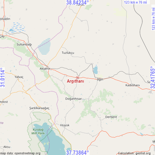
Argıthanı GPS coordinates[2]
38° 17' 33.324" North, 31° 42' 52.272" East
| Map corner | latitude | longitude |
|---|---|---|
| Upper-left | 38.84234°, | 31.0114° |
| Center: | 38.29259°, | 31.71452° |
| Lower-right: | 37.73864°, | 32.41765° |
| Map W x H: | 122.7×122.7 km | = 76.2×76.2mi |
| max Lat: | 42.02683° ⇑56.3% North |
| Argıthanı: | 38.29259° |
| min Lat: | ⇓43.7% South 35.9025° |
| min Long | Argıthanı | max Long |
| 25.90902° | 31.71452° | 44.60099° |
| W 31.9%⇐ | ⇒68.1% E |
Elevation
Elevation of Argıthanı is 1094 m = 3589 ft, and this is 376.6 m = 1236 ft above average elevation for this country.
| Max E: |
2682 m = 8799 ft | 25.7% |
| Argıthanı | 1094 m 3589 ft | |
| Avg. | 717.4 m = 2354 ft | |
Min E: |
0 m = 0 ft | 74.3% |
See also: Turkey elevation on elevation.city.
Geographical zone
Argıthanı is located in North temperate zone (between Tropic of Cancer and the Arctic Circle). Distance of this Northern Tropic circle is 1651.8 km =1026.4 mi to South.| Distance of | km | miles | from Argıthanı |
|---|---|---|---|
| North Pole | 5749.3 | 3572.4 | to North |
| Arctic Circle | 3143.4 | 1953.2 | to North |
| Tropic Cancer | 1651.8 | 1026.4 | to South |
| Equator | 4257.7 | 2645.6 | to South |


Nearby cities:
15 places around Argıthanı: (largest is in red/bold)
• Akşehir
27 km =16.8 mi,  285°
285°
• Aşağıçiğil
29.8 km =18.5 mi,  154°
154°
• Bağkonak
39.5 km =24.5 mi,  257°
257°
• Derbent
40.7 km =25.3 mi,  139°
139°
• Doğanhisar
16.6 km =10.3 mi,  191°
191°
• Hüyük
39.1 km =24.3 mi,  195°
195°
• Ilgın
17.5 km =10.9 mi,  94°
94°
• Kadınhanı
43.8 km =27.2 mi,  97°
97°
• Kurthasanlı
40.4 km =25.1 mi,  84°
84°
• Reis
12.7 km =7.9 mi, 259°
• Sultandağı
50 km =31.1 mi,  302°
302°
• Turgut
38.1 km =23.7 mi,  12°
12°
• Tuzlukçu
22 km =13.7 mi,  339°
339°
• Yalvaç
46.8 km =29.1 mi,  270°
270°
• Şarkîkaraağaç
38.6 km =24 mi,  232°
232°
Sources, notices
• [Note1] Compared only with cities in Turkey existing in our database
• [Src1] Map data: © OpenStreetMap contributors (CC-BY-SA)
• [Src2] Other city data from geonames.org with taken over terms of usage.
• [Src3] Geographical zone / Annual Mean Temperature by Robert A. Rohde @ Wikipedia
