Yunak geodata
Yunak (Konya) is a seat of a second-order administrative division; located in Turkey in Europe/Istanbul (GMT+3) time zone. With population of 14,050 people, there are 406 cities with bigger population in this country. Compared to other cities in Turkey, 52.1% of cities are located further ↓South; 68% of cities are located further →East and 74% of cities have lower elevation than Yunak. Note1


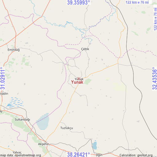
Yunak GPS coordinates[2]
38° 48' 51.048" North, 31° 43' 56.028" East
| Map corner | latitude | longitude |
|---|---|---|
| Upper-left | 39.35993°, | 31.02911° |
| Center: | 38.81418°, | 31.73223° |
| Lower-right: | 38.26421°, | 32.43536° |
| Map W x H: | 121.8×121.8 km | = 75.7×75.7mi |
| max Lat: | 42.02683° ⇑47.9% North |
| Yunak: | 38.81418° |
| min Lat: | ⇓52.1% South 35.9025° |
| min Long | Yunak | max Long |
| 25.90902° | 31.73223° | 44.60099° |
| W 32%⇐ | ⇒68% E |
Elevation
Elevation of Yunak is 1088 m = 3570 ft, and this is 370.6 m = 1216 ft above average elevation for this country.
| Max E: |
2682 m = 8799 ft | 26% |
| Yunak | 1088 m 3570 ft | |
| Avg. | 717.4 m = 2354 ft | |
Min E: |
0 m = 0 ft | 74% |
See also: Turkey elevation on elevation.city.
Geographical zone
Yunak is located in North temperate zone (between Tropic of Cancer and the Arctic Circle). Distance of this Northern Tropic circle is 1709.8 km =1062.4 mi to South.| Distance of | km | miles | from Yunak |
|---|---|---|---|
| North Pole | 5691.3 | 3536.4 | to North |
| Arctic Circle | 3085.4 | 1917.2 | to North |
| Tropic Cancer | 1709.8 | 1062.4 | to South |
| Equator | 4315.7 | 2681.7 | to South |


Nearby cities:
15 places around Yunak: (largest is in red/bold)
• Akşehir
57.7 km =35.9 mi,  208°
208°
• Argıthanı
58 km =36 mi,  181°
181°
• Bolvadin
60.4 km =37.5 mi,  259°
259°
• Davulga
36.2 km =22.5 mi,  300°
300°
• Emirdağ
55.3 km =34.4 mi,  294°
294°
• Günyüzü
63.7 km =39.6 mi,  6°
6°
• Ilgın
61.5 km =38.2 mi,  165°
165°
• Reis
62 km =38.5 mi,  193°
193°
• Sultandağı
53.9 km =33.5 mi,  234°
234°
• Sülüklü
53.4 km =33.2 mi,  81°
81°
• Turgut
21.9 km =13.6 mi,  161°
161°
• Tuzlukçu
38.5 km =23.9 mi, 193°
• Umraniye
58.8 km =36.5 mi,  313°
313°
• Çay
65.9 km =40.9 mi,  247°
247°
• Çeltik
23.9 km =14.9 mi, 12°
Sources, notices
• [Note1] Compared only with cities in Turkey existing in our database
• [Src1] Map data: © OpenStreetMap contributors (CC-BY-SA)
• [Src2] Other city data from geonames.org with taken over terms of usage.
• [Src3] Geographical zone / Annual Mean Temperature by Robert A. Rohde @ Wikipedia
