Reis geodata
Reis (Konya) is a seat of a third-order administrative division; located in Turkey in Europe/Istanbul (GMT+3) time zone. In our database, there are 1323 cities with bigger population. Compared to other cities in Turkey, 56.7% of cities are located further ↑North; 68.6% of cities are located further →East and 73.3% of cities have lower elevation than Reis. Note1


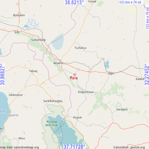
Reis GPS coordinates[2]
38° 16' 17.004" North, 31° 34' 17.004" East
| Map corner | latitude | longitude |
|---|---|---|
| Upper-left | 38.8213°, | 30.86827° |
| Center: | 38.27139°, | 31.57139° |
| Lower-right: | 37.71728°, | 32.27452° |
| Map W x H: | 122.8×122.8 km | = 76.3×76.3mi |
| max Lat: | 42.02683° ⇑56.7% North |
| Reis: | 38.27139° |
| min Lat: | ⇓43.3% South 35.9025° |
| min Long | Reis | max Long |
| 25.90902° | 31.57139° | 44.60099° |
| W 31.4%⇐ | ⇒68.6% E |
Elevation
Elevation of Reis is 1078 m = 3537 ft, and this is 360.6 m = 1183 ft above average elevation for this country.
| Max E: |
2682 m = 8799 ft | 26.7% |
| Reis | 1078 m 3537 ft | |
| Avg. | 717.4 m = 2354 ft | |
Min E: |
0 m = 0 ft | 73.3% |
See also: Turkey elevation on elevation.city.
Geographical zone
Reis is located in North temperate zone (between Tropic of Cancer and the Arctic Circle). Distance of this Northern Tropic circle is 1649.5 km =1025 mi to South.| Distance of | km | miles | from Reis |
|---|---|---|---|
| North Pole | 5751.7 | 3573.9 | to North |
| Arctic Circle | 3145.8 | 1954.7 | to North |
| Tropic Cancer | 1649.5 | 1025 | to South |
| Equator | 4255.4 | 2644.2 | to South |


Nearby cities:
15 places around Reis: (largest is in red/bold)
• Akşehir
16.6 km =10.3 mi,  305°
305°
• Argıthanı
12.7 km =7.9 mi,  79°
79°
• Aşağıçiğil
35.4 km =22 mi,  133°
133°
• Bağkonak
26.8 km =16.7 mi,  257°
257°
• Derbent
48.3 km =30 mi, 126°
• Doğanhisar
16.7 km =10.4 mi,  146°
146°
• Gelendost
51.4 km =31.9 mi,  250°
250°
• Hüyük
35.4 km =22 mi,  176°
176°
• Ilgın
29.9 km =18.6 mi,  88°
88°
• Kumdanlı
52.2 km =32.4 mi,  276°
276°
• Sultandağı
41.6 km =25.8 mi, 313°
• Turgut
44.7 km =27.8 mi,  27°
27°
• Tuzlukçu
23.4 km =14.5 mi,  11°
11°
• Yalvaç
34.5 km =21.4 mi,  274°
274°
• Şarkîkaraağaç
27.9 km =17.3 mi,  220°
220°
Sources, notices
• [Note1] Compared only with cities in Turkey existing in our database
• [Src1] Map data: © OpenStreetMap contributors (CC-BY-SA)
• [Src2] Other city data from geonames.org with taken over terms of usage.
• [Src3] Geographical zone / Annual Mean Temperature by Robert A. Rohde @ Wikipedia
