Hacıbektaş geodata
Hacıbektaş (Nevşehir) is a seat of a second-order administrative division; located in Turkey in Europe/Istanbul (GMT+3) time zone. With population of 6,873 people, there are 615 cities with bigger population in this country. Compared to other cities in Turkey, 53.7% of cities are located further ↓South; 56.3% of cities are located further →East and 83.9% of cities have lower elevation than Hacıbektaş. Note1


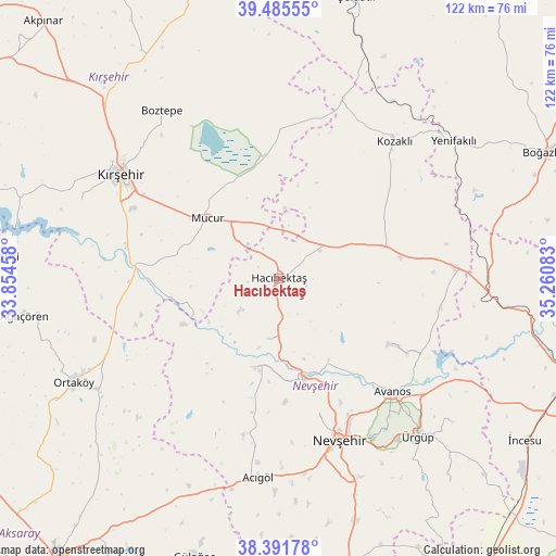
Hacıbektaş GPS coordinates[2]
38° 56' 26.772" North, 34° 33' 27.72" East
| Map corner | latitude | longitude |
|---|---|---|
| Upper-left | 39.48555°, | 33.85458° |
| Center: | 38.94077°, | 34.5577° |
| Lower-right: | 38.39178°, | 35.26083° |
| Map W x H: | 121.6×121.6 km | = 75.6×75.6mi |
| max Lat: | 42.02683° ⇑46.3% North |
| Hacıbektaş: | 38.94077° |
| min Lat: | ⇓53.7% South 35.9025° |
| min Long | Hacıbektaş | max Long |
| 25.90902° | 34.5577° | 44.60099° |
| W 43.7%⇐ | ⇒56.3% E |
Elevation
Elevation of Hacıbektaş is 1284 m = 4213 ft, and this is 566.6 m = 1859 ft above average elevation for this country.
| Max E: |
2682 m = 8799 ft | 16.1% |
| Hacıbektaş | 1284 m 4213 ft | |
| Avg. | 717.4 m = 2354 ft | |
Min E: |
0 m = 0 ft | 83.9% |
See also: Turkey elevation on elevation.city.
Geographical zone
Hacıbektaş is located in North temperate zone (between Tropic of Cancer and the Arctic Circle). Distance of this Northern Tropic circle is 1723.9 km =1071.2 mi to South.| Distance of | km | miles | from Hacıbektaş |
|---|---|---|---|
| North Pole | 5677.3 | 3527.7 | to North |
| Arctic Circle | 3071.4 | 1908.5 | to North |
| Tropic Cancer | 1723.9 | 1071.2 | to South |
| Equator | 4329.8 | 2690.4 | to South |


Nearby cities:
15 places around Hacıbektaş: (largest is in red/bold)
• Acıgöl
43.6 km =27.1 mi,  185°
185°
• Avanos
35.5 km =22.1 mi,  135°
135°
• Balcı
46.2 km =28.7 mi,  238°
238°
• Boztepe
44.6 km =27.7 mi,  325°
325°
• Göreme
40.9 km =25.4 mi, 143°
• Gülşehir
22.4 km =13.9 mi,  164°
164°
• Karahasanlı
42 km =26.1 mi,  19°
19°
• Kozaklı
40.2 km =25 mi,  39°
39°
• Kırşehir
40.9 km =25.4 mi,  303°
303°
• Mucur
20.2 km =12.6 mi,  311°
311°
• Nevşehir
37.6 km =23.4 mi, 159°
• Salanda
13 km =8.1 mi, 189°
• Topaklı
24.3 km =15.1 mi,  72°
72°
• Özonak
28.4 km =17.6 mi,  120°
120°
• Ürgüp
46.3 km =28.8 mi, 138°
Sources, notices
• [Note1] Compared only with cities in Turkey existing in our database
• [Src1] Map data: © OpenStreetMap contributors (CC-BY-SA)
• [Src2] Other city data from geonames.org with taken over terms of usage.
• [Src3] Geographical zone / Annual Mean Temperature by Robert A. Rohde @ Wikipedia
