Mucur geodata
Mucur (Kırşehir) is a seat of a second-order administrative division; located in Turkey in Europe/Istanbul (GMT+3) time zone. With population of 16,522 people, there are 373 cities with bigger population in this country. Compared to other cities in Turkey, 55.4% of cities are located further ↓South; 57% of cities are located further →East and 73.7% of cities have lower elevation than Mucur. Note1


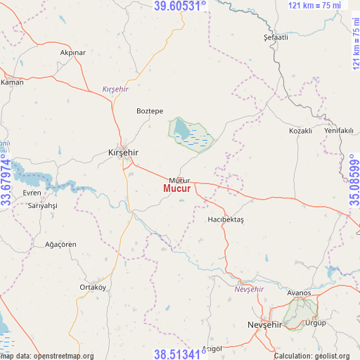
Mucur GPS coordinates[2]
39° 3' 41.292" North, 34° 22' 58.296" East
| Map corner | latitude | longitude |
|---|---|---|
| Upper-left | 39.60531°, | 33.67974° |
| Center: | 39.06147°, | 34.38286° |
| Lower-right: | 38.51341°, | 35.08599° |
| Map W x H: | 121.4×121.4 km | = 75.4×75.4mi |
| max Lat: | 42.02683° ⇑44.6% North |
| Mucur: | 39.06147° |
| min Lat: | ⇓55.4% South 35.9025° |
| min Long | Mucur | max Long |
| 25.90902° | 34.38286° | 44.60099° |
| W 43%⇐ | ⇒57% E |
Elevation
Elevation of Mucur is 1084 m = 3556 ft, and this is 366.6 m = 1203 ft above average elevation for this country.
| Max E: |
2682 m = 8799 ft | 26.3% |
| Mucur | 1084 m 3556 ft | |
| Avg. | 717.4 m = 2354 ft | |
Min E: |
0 m = 0 ft | 73.7% |
See also: Turkey elevation on elevation.city.
Geographical zone
Mucur is located in North temperate zone (between Tropic of Cancer and the Arctic Circle). Distance of this Northern Tropic circle is 1737.3 km =1079.5 mi to South.| Distance of | km | miles | from Mucur |
|---|---|---|---|
| North Pole | 5663.8 | 3519.3 | to North |
| Arctic Circle | 3057.9 | 1900.1 | to North |
| Tropic Cancer | 1737.3 | 1079.5 | to South |
| Equator | 4343.2 | 2698.7 | to South |


Nearby cities:
15 places around Mucur: (largest is in red/bold)
• Ağaçören
45.3 km =28.1 mi,  242°
242°
• Balcı
44.6 km =27.7 mi,  213°
213°
• Boztepe
25.4 km =15.8 mi,  335°
335°
• Evren
50 km =31.1 mi,  265°
265°
• Göllü
43.8 km =27.2 mi,  350°
350°
• Gülşehir
40.9 km =25.4 mi,  149°
149°
• Hacıbektaş
20.2 km =12.6 mi,  131°
131°
• Karahasanlı
39.2 km =24.4 mi,  48°
48°
• Kozaklı
44.1 km =27.4 mi,  66°
66°
• Kırşehir
21.1 km =13.1 mi,  296°
296°
• Ortaköy
46.8 km =29.1 mi,  219°
219°
• Salanda
29.2 km =18.1 mi, 153°
• Sarıyahşi
47.6 km =29.6 mi,  259°
259°
• Topaklı
38.8 km =24.1 mi,  99°
99°
• Özonak
48.4 km =30.1 mi,  124°
124°
Sources, notices
• [Note1] Compared only with cities in Turkey existing in our database
• [Src1] Map data: © OpenStreetMap contributors (CC-BY-SA)
• [Src2] Other city data from geonames.org with taken over terms of usage.
• [Src3] Geographical zone / Annual Mean Temperature by Robert A. Rohde @ Wikipedia
