Gördes geodata
Gördes (Manisa) is a seat of a second-order administrative division; located in Turkey in Europe/Istanbul (GMT+3) time zone. With population of 11,168 people, there are 478 cities with bigger population in this country. Compared to other cities in Turkey, 53.5% of cities are located further ↓South; 88.2% of cities are located further →East and 51.3% of cities have higher elevation than Gördes. Note1


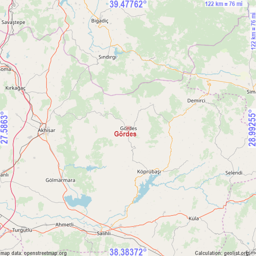
Gördes GPS coordinates[2]
38° 55' 58.008" North, 28° 17' 21.912" East
| Map corner | latitude | longitude |
|---|---|---|
| Upper-left | 39.47762°, | 27.5863° |
| Center: | 38.93278°, | 28.28942° |
| Lower-right: | 38.38372°, | 28.99255° |
| Map W x H: | 121.6×121.6 km | = 75.6×75.6mi |
| max Lat: | 42.02683° ⇑46.5% North |
| Gördes: | 38.93278° |
| min Lat: | ⇓53.5% South 35.9025° |
| min Long | Gördes | max Long |
| 25.90902° | 28.28942° | 44.60099° |
| W 11.8%⇐ | ⇒88.2% E |
Elevation
Elevation of Gördes is 671 m = 2201 ft, and this is 46.4 m = 152 ft below average elevation for this country.
| Max E: |
2682 m = 8799 ft | 51.3% |
| Avg. | 717.4 m = 2354 ft | |
| Gördes | 671 m = 2201 ft | |
Min E: |
0 m = 0 ft | 48.7% |
See also: Turkey elevation on elevation.city.
Geographical zone
Gördes is located in North temperate zone (between Tropic of Cancer and the Arctic Circle). Distance of this Northern Tropic circle is 1723 km =1070.6 mi to South.| Distance of | km | miles | from Gördes |
|---|---|---|---|
| North Pole | 5678.1 | 3528.2 | to North |
| Arctic Circle | 3072.3 | 1909 | to North |
| Tropic Cancer | 1723 | 1070.6 | to South |
| Equator | 4328.9 | 2689.9 | to South |


Nearby cities:
15 places around Gördes: (largest is in red/bold)
• Adala
39.5 km =24.5 mi,  182°
182°
• Akhisar
38.9 km =24.2 mi,  267°
267°
• Bigadiç
52.9 km =32.9 mi,  345°
345°
• Borlu
25.3 km =15.7 mi,  142°
142°
• Demirci
34.3 km =21.3 mi,  68°
68°
• Düvertepe
36.3 km =22.6 mi,  20°
20°
• Gelembe
46.9 km =29.1 mi,  305°
305°
• Gölcük
49.9 km =31 mi,  328°
328°
• Gölmarmara
40.6 km =25.2 mi,  233°
233°
• Kula
53 km =32.9 mi, 143°
• Köprübaşı
22.7 km =14.1 mi,  153°
153°
• Menye
43.4 km =27 mi,  156°
156°
• Salihli
51.5 km =32 mi,  193°
193°
• Sındırgı
35.6 km =22.1 mi,  344°
344°
• Yarbasan
45.3 km =28.1 mi,  82°
82°
Sources, notices
• [Note1] Compared only with cities in Turkey existing in our database
• [Src1] Map data: © OpenStreetMap contributors (CC-BY-SA)
• [Src2] Other city data from geonames.org with taken over terms of usage.
• [Src3] Geographical zone / Annual Mean Temperature by Robert A. Rohde @ Wikipedia
