Gelembe geodata
Gelembe (Manisa) is a seat of a third-order administrative division; located in Turkey in Europe/Istanbul (GMT+3) time zone. In our database, there are 1323 cities with bigger population. Compared to other cities in Turkey, 57.1% of cities are located further ↓South; 91.2% of cities are located further →East and 71.9% of cities have higher elevation than Gelembe. Note1


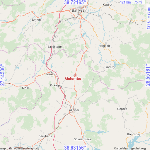
Gelembe GPS coordinates[2]
39° 10' 43.392" North, 27° 50' 54.528" East
| Map corner | latitude | longitude |
|---|---|---|
| Upper-left | 39.72165°, | 27.14536° |
| Center: | 39.17872°, | 27.84848° |
| Lower-right: | 38.63156°, | 28.55161° |
| Map W x H: | 121.2×121.2 km | = 75.3×75.3mi |
| max Lat: | 42.02683° ⇑42.9% North |
| Gelembe: | 39.17872° |
| min Lat: | ⇓57.1% South 35.9025° |
| min Long | Gelembe | max Long |
| 25.90902° | 27.84848° | 44.60099° |
| W 8.8%⇐ | ⇒91.2% E |
Elevation
Elevation of Gelembe is 238 m = 781 ft, and this is 479.4 m = 1573 ft below average elevation for this country.
| Max E: |
2682 m = 8799 ft | 71.9% |
| Avg. | 717.4 m = 2354 ft | |
| Gelembe | 238 m = 781 ft | |
Min E: |
0 m = 0 ft | 28.1% |
See also: Turkey elevation on elevation.city.
Geographical zone
Gelembe is located in North temperate zone (between Tropic of Cancer and the Arctic Circle). Distance of this Northern Tropic circle is 1750.3 km =1087.6 mi to South.| Distance of | km | miles | from Gelembe |
|---|---|---|---|
| North Pole | 5650.8 | 3511.2 | to North |
| Arctic Circle | 3044.9 | 1892 | to North |
| Tropic Cancer | 1750.3 | 1087.6 | to South |
| Equator | 4356.3 | 2706.9 | to South |


Nearby cities:
15 places around Gelembe: (largest is in red/bold)
• Akhisar
28.9 km =18 mi,  181°
181°
• Bigadiç
34 km =21.1 mi,  45°
45°
• Ertuğrul
45.8 km =28.5 mi,  344°
344°
• Gölcük
18.9 km =11.7 mi,  37°
37°
• Göçbeyli
38.6 km =24 mi,  277°
277°
• Konakpınar
28.4 km =17.6 mi,  357°
357°
• Kınık
41.4 km =25.7 mi,  255°
255°
• Kırkağaç
17.4 km =10.8 mi,  242°
242°
• Sarıbeyler
33.8 km =21 mi,  316°
316°
• Savaştepe
28.1 km =17.5 mi, 323°
• Soma
20.6 km =12.8 mi,  272°
272°
• Sındırgı
29.3 km =18.2 mi,  76°
76°
• Turanlı
46.4 km =28.8 mi, 283°
• Zeytinliova
25.6 km =15.9 mi,  215°
215°
• Çağış
40.4 km =25.1 mi,  20°
20°
Sources, notices
• [Note1] Compared only with cities in Turkey existing in our database
• [Src1] Map data: © OpenStreetMap contributors (CC-BY-SA)
• [Src2] Other city data from geonames.org with taken over terms of usage.
• [Src3] Geographical zone / Annual Mean Temperature by Robert A. Rohde @ Wikipedia
