Kırkağaç geodata
Kırkağaç (Manisa) is a seat of a second-order administrative division; located in Turkey in Europe/Istanbul (GMT+3) time zone. With population of 27,053 people, there are 270 cities with bigger population in this country. Compared to other cities in Turkey, 56.1% of cities are located further ↓South; 92.4% of cities are located further →East and 73% of cities have higher elevation than Kırkağaç. Note1


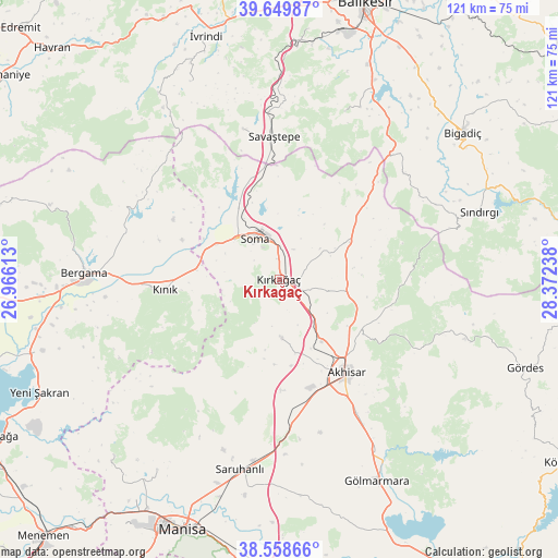
Kırkağaç GPS coordinates[2]
39° 6' 22.968" North, 27° 40' 9.3" East
| Map corner | latitude | longitude |
|---|---|---|
| Upper-left | 39.64987°, | 26.96613° |
| Center: | 39.10638°, | 27.66925° |
| Lower-right: | 38.55866°, | 28.37238° |
| Map W x H: | 121.3×121.3 km | = 75.4×75.4mi |
| max Lat: | 42.02683° ⇑43.9% North |
| Kırkağaç: | 39.10638° |
| min Lat: | ⇓56.1% South 35.9025° |
| min Long | Kırkağaç | max Long |
| 25.90902° | 27.66925° | 44.60099° |
| W 7.6%⇐ | ⇒92.4% E |
Elevation
Elevation of Kırkağaç is 213 m = 699 ft, and this is 504.4 m = 1655 ft below average elevation for this country.
| Max E: |
2682 m = 8799 ft | 73% |
| Avg. | 717.4 m = 2354 ft | |
| Kırkağaç | 213 m = 699 ft | |
Min E: |
0 m = 0 ft | 27% |
See also: Turkey elevation on elevation.city.
Geographical zone
Kırkağaç is located in North temperate zone (between Tropic of Cancer and the Arctic Circle). Distance of this Northern Tropic circle is 1742.3 km =1082.6 mi to South.| Distance of | km | miles | from Kırkağaç |
|---|---|---|---|
| North Pole | 5658.8 | 3516.2 | to North |
| Arctic Circle | 3053 | 1897 | to North |
| Tropic Cancer | 1742.3 | 1082.6 | to South |
| Equator | 4348.2 | 2701.8 | to South |


Nearby cities:
15 places around Kırkağaç: (largest is in red/bold)
• Akhisar
25.6 km =15.9 mi,  144°
144°
• Bergama
42.2 km =26.2 mi,  272°
272°
• Gelembe
17.4 km =10.8 mi,  62°
62°
• Gölcük
35.5 km =22.1 mi,  49°
49°
• Göçbeyli
26.3 km =16.3 mi,  299°
299°
• Konakpınar
39.1 km =24.3 mi,  21°
21°
• Kınık
24.8 km =15.4 mi, 265°
• Saruhanlı
42.3 km =26.3 mi,  191°
191°
• Sarıbeyler
33.4 km =20.8 mi,  346°
346°
• Savaştepe
30.8 km =19.1 mi,  357°
357°
• Soma
10.2 km =6.3 mi,  329°
329°
• Sındırgı
46.4 km =28.8 mi,  71°
71°
• Turanlı
35.2 km =21.9 mi, 302°
• Yuntdağ
43.9 km =27.3 mi,  243°
243°
• Zeytinliova
12.8 km =8 mi,  177°
177°
Sources, notices
• [Note1] Compared only with cities in Turkey existing in our database
• [Src1] Map data: © OpenStreetMap contributors (CC-BY-SA)
• [Src2] Other city data from geonames.org with taken over terms of usage.
• [Src3] Geographical zone / Annual Mean Temperature by Robert A. Rohde @ Wikipedia
