Bozkır geodata
Bozkır (Konya) is a seat of a second-order administrative division; located in Turkey in Europe/Istanbul (GMT+3) time zone. With population of 10,958 people, there are 486 cities with bigger population in this country. Compared to other cities in Turkey, 83.7% of cities are located further ↑North; 65.5% of cities are located further →East and 76.8% of cities have lower elevation than Bozkır. Note1


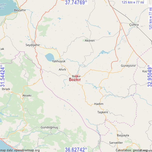
Bozkır GPS coordinates[2]
37° 11' 22.668" North, 32° 14' 50.496" East
| Map corner | latitude | longitude |
|---|---|---|
| Upper-left | 37.74769°, | 31.54424° |
| Center: | 37.18963°, | 32.24736° |
| Lower-right: | 36.62742°, | 32.95049° |
| Map W x H: | 124.6×124.6 km | = 77.4×77.4mi |
| max Lat: | 42.02683° ⇑83.7% North |
| Bozkır: | 37.18963° |
| min Lat: | ⇓16.3% South 35.9025° |
| min Long | Bozkır | max Long |
| 25.90902° | 32.24736° | 44.60099° |
| W 34.5%⇐ | ⇒65.5% E |
Elevation
Elevation of Bozkır is 1135 m = 3724 ft, and this is 417.6 m = 1370 ft above average elevation for this country.
| Max E: |
2682 m = 8799 ft | 23.2% |
| Bozkır | 1135 m 3724 ft | |
| Avg. | 717.4 m = 2354 ft | |
Min E: |
0 m = 0 ft | 76.8% |
See also: Turkey elevation on elevation.city.
Geographical zone
Bozkır is located in North temperate zone (between Tropic of Cancer and the Arctic Circle). Distance of this Northern Tropic circle is 1529.2 km =950.2 mi to South.| Distance of | km | miles | from Bozkır |
|---|---|---|---|
| North Pole | 5872 | 3648.7 | to North |
| Arctic Circle | 3266.1 | 2029.5 | to North |
| Tropic Cancer | 1529.2 | 950.2 | to South |
| Equator | 4135.1 | 2569.4 | to South |


Nearby cities:
15 places around Bozkır: (largest is in red/bold)
• Ahırlı
12.6 km =7.8 mi,  295°
295°
• Akseki
43.5 km =27 mi,  248°
248°
• Akören
31.3 km =19.4 mi,  20°
20°
• Belören
27.3 km =17 mi,  84°
84°
• Cevizli
42.9 km =26.7 mi,  271°
271°
• Dinek
35.9 km =22.3 mi,  65°
65°
• Eksere
47.3 km =29.4 mi,  207°
207°
• Güneysınır
43.6 km =27.1 mi, 78°
• Güzelsu
47.7 km =29.6 mi,  226°
226°
• Hadim
29.1 km =18.1 mi,  140°
140°
• Hatunsaray
45.1 km =28 mi,  11°
11°
• Seydişehir
43.8 km =27.2 mi,  305°
305°
• Taşkent
36.6 km =22.7 mi, 143°
• Yalıhüyük
18.9 km =11.7 mi, 310°
• Üçpınar
6.3 km =3.9 mi,  168°
168°
Sources, notices
• [Note1] Compared only with cities in Turkey existing in our database
• [Src1] Map data: © OpenStreetMap contributors (CC-BY-SA)
• [Src2] Other city data from geonames.org with taken over terms of usage.
• [Src3] Geographical zone / Annual Mean Temperature by Robert A. Rohde @ Wikipedia
