Üçpınar geodata
Üçpınar (Konya) is a seat of a third-order administrative division; located in Turkey in Europe/Istanbul (GMT+3) time zone. In our database, there are 1323 cities with bigger population. Compared to other cities in Turkey, 85.6% of cities are located further ↑North; 65.4% of cities are located further →East and 90% of cities have lower elevation than Üçpınar. Note1


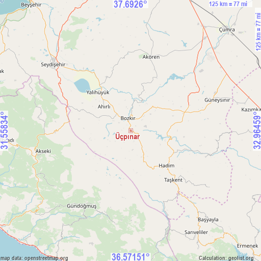
Üçpınar GPS coordinates[2]
37° 8' 2.868" North, 32° 15' 41.256" East
| Map corner | latitude | longitude |
|---|---|---|
| Upper-left | 37.6926°, | 31.55834° |
| Center: | 37.13413°, | 32.26146° |
| Lower-right: | 36.57151°, | 32.96459° |
| Map W x H: | 124.7×124.7 km | = 77.5×77.5mi |
| max Lat: | 42.02683° ⇑85.6% North |
| Üçpınar: | 37.13413° |
| min Lat: | ⇓14.4% South 35.9025° |
| min Long | Üçpınar | max Long |
| 25.90902° | 32.26146° | 44.60099° |
| W 34.6%⇐ | ⇒65.4% E |
Elevation
Elevation of Üçpınar is 1476 m = 4843 ft, and this is 758.6 m = 2489 ft above average elevation for this country.
| Max E: |
2682 m = 8799 ft | 10% |
| Üçpınar | 1476 m 4843 ft | |
| Avg. | 717.4 m = 2354 ft | |
Min E: |
0 m = 0 ft | 90% |
See also: Turkey elevation on elevation.city.
Geographical zone
Üçpınar is located in North temperate zone (between Tropic of Cancer and the Arctic Circle). Distance of this Northern Tropic circle is 1523 km =946.3 mi to South.| Distance of | km | miles | from Üçpınar |
|---|---|---|---|
| North Pole | 5878.1 | 3652.5 | to North |
| Arctic Circle | 3272.2 | 2033.3 | to North |
| Tropic Cancer | 1523 | 946.3 | to South |
| Equator | 4128.9 | 2565.6 | to South |


Nearby cities:
15 places around Üçpınar: (largest is in red/bold)
• Ahırlı
17.2 km =10.7 mi,  312°
312°
• Akseki
42.9 km =26.7 mi,  257°
257°
• Akören
36.8 km =22.9 mi,  15°
15°
• Belören
27.4 km =17 mi,  70°
70°
• Bozkır
6.3 km =3.9 mi,  348°
348°
• Cevizli
44.7 km =27.8 mi,  278°
278°
• Dinek
37.9 km =23.5 mi,  55°
55°
• Eksere
42.6 km =26.5 mi,  213°
213°
• Güneysınır
44.1 km =27.4 mi, 70°
• Güzelsu
44.7 km =27.8 mi,  233°
233°
• Hadim
23.8 km =14.8 mi,  133°
133°
• Köprülü
45.2 km =28.1 mi,  188°
188°
• Seydişehir
48.6 km =30.2 mi, 310°
• Taşkent
31 km =19.3 mi,  138°
138°
• Yalıhüyük
24.2 km =15 mi,  319°
319°
Sources, notices
• [Note1] Compared only with cities in Turkey existing in our database
• [Src1] Map data: © OpenStreetMap contributors (CC-BY-SA)
• [Src2] Other city data from geonames.org with taken over terms of usage.
• [Src3] Geographical zone / Annual Mean Temperature by Robert A. Rohde @ Wikipedia
