Senirkent geodata
Senirkent (Isparta) is a seat of a second-order administrative division; located in Turkey in Europe/Istanbul (GMT+3) time zone. With population of 15,919 people, there are 380 cities with bigger population in this country. Compared to other cities in Turkey, 59.7% of cities are located further ↑North; 72.6% of cities are located further →East and 69.7% of cities have lower elevation than Senirkent. Note1


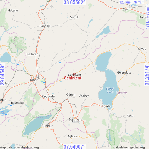
Senirkent GPS coordinates[2]
38° 6' 15.984" North, 30° 32' 54.996" East
| Map corner | latitude | longitude |
|---|---|---|
| Upper-left | 38.65562°, | 29.84549° |
| Center: | 38.10444°, | 30.54861° |
| Lower-right: | 37.54907°, | 31.25174° |
| Map W x H: | 123×123 km | = 76.4×76.4mi |
| max Lat: | 42.02683° ⇑59.7% North |
| Senirkent: | 38.10444° |
| min Lat: | ⇓40.3% South 35.9025° |
| min Long | Senirkent | max Long |
| 25.90902° | 30.54861° | 44.60099° |
| W 27.4%⇐ | ⇒72.6% E |
Elevation
Elevation of Senirkent is 1024 m = 3360 ft, and this is 306.6 m = 1006 ft above average elevation for this country.
| Max E: |
2682 m = 8799 ft | 30.3% |
| Senirkent | 1024 m 3360 ft | |
| Avg. | 717.4 m = 2354 ft | |
Min E: |
0 m = 0 ft | 69.7% |
See also: Turkey elevation on elevation.city.
Geographical zone
Senirkent is located in North temperate zone (between Tropic of Cancer and the Arctic Circle). Distance of this Northern Tropic circle is 1630.9 km =1013.4 mi to South.| Distance of | km | miles | from Senirkent |
|---|---|---|---|
| North Pole | 5770.2 | 3585.4 | to North |
| Arctic Circle | 3164.4 | 1966.3 | to North |
| Tropic Cancer | 1630.9 | 1013.4 | to South |
| Equator | 4236.8 | 2632.6 | to South |


Nearby cities:
15 places around Senirkent: (largest is in red/bold)
• Anamas
43.5 km =27 mi,  149°
149°
• Atabey
18.8 km =11.7 mi,  155°
155°
• Barla
22.7 km =14.1 mi,  115°
115°
• Dinar
33.8 km =21 mi,  262°
262°
• Dombay
30.2 km =18.8 mi,  280°
280°
• Eğirdir
36.8 km =22.9 mi,  134°
134°
• Gelendost
40.9 km =25.4 mi,  87°
87°
• Gönen
16.8 km =10.4 mi,  191°
191°
• Haydarlı
22.4 km =13.9 mi,  320°
320°
• Isparta
37.8 km =23.5 mi,  179°
179°
• Keçiborlu
28.1 km =17.5 mi,  230°
230°
• Kumdanlı
44.6 km =27.7 mi,  56°
56°
• Kızılören
38.7 km =24 mi,  296°
296°
• Sandıklı
46.9 km =29.1 mi,  328°
328°
• Uluborlu
9.1 km =5.7 mi,  251°
251°
Sources, notices
• [Note1] Compared only with cities in Turkey existing in our database
• [Src1] Map data: © OpenStreetMap contributors (CC-BY-SA)
• [Src2] Other city data from geonames.org with taken over terms of usage.
• [Src3] Geographical zone / Annual Mean Temperature by Robert A. Rohde @ Wikipedia
