Isparta geodata
Isparta is a seat of a first-order administrative division; located in Turkey in Europe/Istanbul (GMT+3) time zone. With population of 172,334 people, there are 57 cities with bigger population in this country. Compared to other cities in Turkey, 69.1% of cities are located further ↑North; 72.5% of cities are located further →East and 72.9% of cities have lower elevation than Isparta. Note1


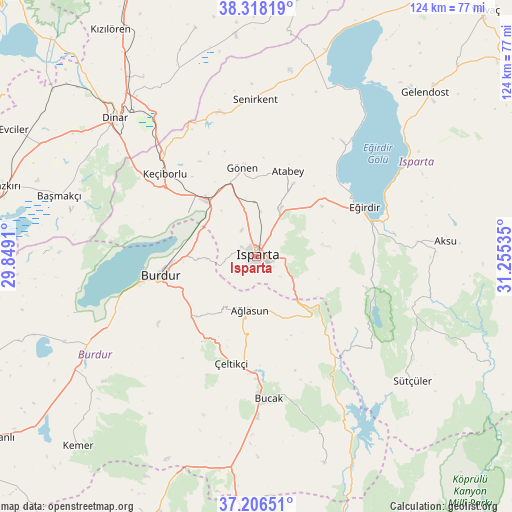
Isparta GPS coordinates[2]
37° 45' 51.984" North, 30° 33' 7.992" East
| Map corner | latitude | longitude |
|---|---|---|
| Upper-left | 38.31819°, | 29.8491° |
| Center: | 37.76444°, | 30.55222° |
| Lower-right: | 37.20651°, | 31.25535° |
| Map W x H: | 123.6×123.6 km | = 76.8×76.8mi |
| max Lat: | 42.02683° ⇑69.1% North |
| Isparta: | 37.76444° |
| min Lat: | ⇓30.9% South 35.9025° |
| min Long | Isparta | max Long |
| 25.90902° | 30.55222° | 44.60099° |
| W 27.5%⇐ | ⇒72.5% E |
Elevation
Elevation of Isparta is 1069 m = 3507 ft, and this is 351.6 m = 1154 ft above average elevation for this country.
| Max E: |
2682 m = 8799 ft | 27.1% |
| Isparta | 1069 m 3507 ft | |
| Avg. | 717.4 m = 2354 ft | |
Min E: |
0 m = 0 ft | 72.9% |
See also: Isparta elevation on elevation.city.
Geographical zone
Isparta is located in North temperate zone (between Tropic of Cancer and the Arctic Circle). Distance of this Northern Tropic circle is 1593.1 km =989.9 mi to South.| Distance of | km | miles | from Isparta |
|---|---|---|---|
| North Pole | 5808 | 3608.9 | to North |
| Arctic Circle | 3202.2 | 1989.8 | to North |
| Tropic Cancer | 1593.1 | 989.9 | to South |
| Equator | 4199 | 2609.1 | to South |


Nearby cities:
15 places around Isparta: (largest is in red/bold)
• Aksu
45.8 km =28.5 mi,  85°
85°
• Anamas
21.8 km =13.5 mi, 89°
• Atabey
22.1 km =13.7 mi,  20°
20°
• Ağlasun
12.9 km =8 mi,  187°
187°
• Barla
34.7 km =21.6 mi,  35°
35°
• Bucak
34.2 km =21.3 mi,  173°
173°
• Burdur
23.5 km =14.6 mi,  257°
257°
• Dinar
47.6 km =29.6 mi,  314°
314°
• Eğirdir
28.9 km =18 mi,  64°
64°
• Gönen
21.6 km =13.4 mi,  350°
350°
• Keçiborlu
29.6 km =18.4 mi, 312°
• Pavlu Cebel
47.8 km =29.7 mi,  128°
128°
• Senirkent
37.8 km =23.5 mi,  359°
359°
• Uluborlu
36 km =22.4 mi, 345°
• Çeltikçi
26.9 km =16.7 mi, 193°
Sources, notices
• [Note1] Compared only with cities in Turkey existing in our database
• [Src1] Map data: © OpenStreetMap contributors (CC-BY-SA)
• [Src2] Other city data from geonames.org with taken over terms of usage.
• [Src3] Geographical zone / Annual Mean Temperature by Robert A. Rohde @ Wikipedia
