Barla geodata
Barla (Isparta) is a seat of a third-order administrative division; located in Turkey in Europe/Istanbul (GMT+3) time zone. In our database, there are 1323 cities with bigger population. Compared to other cities in Turkey, 61% of cities are located further ↑North; 71.5% of cities are located further →East and 75.2% of cities have lower elevation than Barla. Note1


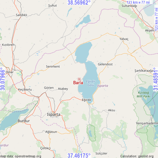
Barla GPS coordinates[2]
38° 1' 4.008" North, 30° 46' 58.008" East
| Map corner | latitude | longitude |
|---|---|---|
| Upper-left | 38.56962°, | 30.07966° |
| Center: | 38.01778°, | 30.78278° |
| Lower-right: | 37.46175°, | 31.48591° |
| Map W x H: | 123.2×123.2 km | = 76.6×76.6mi |
| max Lat: | 42.02683° ⇑61% North |
| Barla: | 38.01778° |
| min Lat: | ⇓39% South 35.9025° |
| min Long | Barla | max Long |
| 25.90902° | 30.78278° | 44.60099° |
| W 28.5%⇐ | ⇒71.5% E |
Elevation
Elevation of Barla is 1108 m = 3635 ft, and this is 390.6 m = 1281 ft above average elevation for this country.
| Max E: |
2682 m = 8799 ft | 24.8% |
| Barla | 1108 m 3635 ft | |
| Avg. | 717.4 m = 2354 ft | |
Min E: |
0 m = 0 ft | 75.2% |
See also: Turkey elevation on elevation.city.
Geographical zone
Barla is located in North temperate zone (between Tropic of Cancer and the Arctic Circle). Distance of this Northern Tropic circle is 1621.3 km =1007.4 mi to South.| Distance of | km | miles | from Barla |
|---|---|---|---|
| North Pole | 5779.9 | 3591.5 | to North |
| Arctic Circle | 3174 | 1972.2 | to North |
| Tropic Cancer | 1621.3 | 1007.4 | to South |
| Equator | 4227.2 | 2626.7 | to South |


Nearby cities:
15 places around Barla: (largest is in red/bold)
• Aksu
35.1 km =21.8 mi,  133°
133°
• Anamas
28 km =17.4 mi,  176°
176°
• Atabey
14.7 km =9.1 mi,  239°
239°
• Ağlasun
46.4 km =28.8 mi,  208°
208°
• Bağkonak
48.2 km =30 mi,  62°
62°
• Eğirdir
17 km =10.6 mi,  159°
159°
• Gelendost
23.4 km =14.5 mi, 60°
• Gönen
24.7 km =15.3 mi,  253°
253°
• Haydarlı
43.9 km =27.3 mi,  307°
307°
• Isparta
34.7 km =21.6 mi,  215°
215°
• Keçiborlu
42.9 km =26.7 mi,  258°
258°
• Kumdanlı
38 km =23.6 mi,  26°
26°
• Senirkent
22.7 km =14.1 mi,  295°
295°
• Uluborlu
29.9 km =18.6 mi,  283°
283°
• Yalvaç
46.3 km =28.8 mi,  48°
48°
Sources, notices
• [Note1] Compared only with cities in Turkey existing in our database
• [Src1] Map data: © OpenStreetMap contributors (CC-BY-SA)
• [Src2] Other city data from geonames.org with taken over terms of usage.
• [Src3] Geographical zone / Annual Mean Temperature by Robert A. Rohde @ Wikipedia
