Uluborlu geodata
Uluborlu (Isparta) is a seat of a second-order administrative division; located in Turkey in Europe/Istanbul (GMT+3) time zone. With population of 12,514 people, there are 440 cities with bigger population in this country. Compared to other cities in Turkey, 60.2% of cities are located further ↑North; 73.5% of cities are located further →East and 71.7% of cities have lower elevation than Uluborlu. Note1


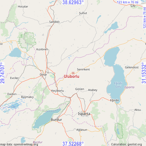
Uluborlu GPS coordinates[2]
38° 4' 41.7" North, 30° 27' 0.684" East
| Map corner | latitude | longitude |
|---|---|---|
| Upper-left | 38.62963°, | 29.74707° |
| Center: | 38.07825°, | 30.45019° |
| Lower-right: | 37.52268°, | 31.15332° |
| Map W x H: | 123.1×123.1 km | = 76.5×76.5mi |
| max Lat: | 42.02683° ⇑60.2% North |
| Uluborlu: | 38.07825° |
| min Lat: | ⇓39.8% South 35.9025° |
| min Long | Uluborlu | max Long |
| 25.90902° | 30.45019° | 44.60099° |
| W 26.5%⇐ | ⇒73.5% E |
Elevation
Elevation of Uluborlu is 1050 m = 3445 ft, and this is 332.6 m = 1091 ft above average elevation for this country.
| Max E: |
2682 m = 8799 ft | 28.3% |
| Uluborlu | 1050 m 3445 ft | |
| Avg. | 717.4 m = 2354 ft | |
Min E: |
0 m = 0 ft | 71.7% |
See also: Turkey elevation on elevation.city.
Geographical zone
Uluborlu is located in North temperate zone (between Tropic of Cancer and the Arctic Circle). Distance of this Northern Tropic circle is 1628 km =1011.6 mi to South.| Distance of | km | miles | from Uluborlu |
|---|---|---|---|
| North Pole | 5773.2 | 3587.3 | to North |
| Arctic Circle | 3167.3 | 1968.1 | to North |
| Tropic Cancer | 1628 | 1011.6 | to South |
| Equator | 4233.9 | 2630.8 | to South |


Nearby cities:
15 places around Uluborlu: (largest is in red/bold)
• Atabey
21.8 km =13.5 mi,  130°
130°
• Barla
29.9 km =18.6 mi,  103°
103°
• Başmakçı
43.4 km =27 mi,  242°
242°
• Burdur
42.2 km =26.2 mi,  199°
199°
• Dinar
25 km =15.5 mi,  266°
266°
• Dombay
22.7 km =14.1 mi,  291°
291°
• Eğirdir
41.8 km =26 mi,  122°
122°
• Gönen
14.6 km =9.1 mi,  158°
158°
• Haydarlı
20.9 km =13 mi,  344°
344°
• Homa
44.3 km =27.5 mi, 293°
• Isparta
36 km =22.4 mi,  165°
165°
• Keçiborlu
19.9 km =12.4 mi,  220°
220°
• Kızılören
32.9 km =20.4 mi,  307°
307°
• Senirkent
9.1 km =5.7 mi,  71°
71°
• İshaklı
40.5 km =25.2 mi, 289°
Sources, notices
• [Note1] Compared only with cities in Turkey existing in our database
• [Src1] Map data: © OpenStreetMap contributors (CC-BY-SA)
• [Src2] Other city data from geonames.org with taken over terms of usage.
• [Src3] Geographical zone / Annual Mean Temperature by Robert A. Rohde @ Wikipedia
