Eğirdir geodata
Eğirdir (Isparta) is a populated place; located in Turkey in Europe/Istanbul (GMT+3) time zone. With population of 17,228 people, there are 359 cities with bigger population in this country. Compared to other cities in Turkey, 66.1% of cities are located further ↑North; 71.2% of cities are located further →East and 62.6% of cities have lower elevation than Eğirdir. Note1


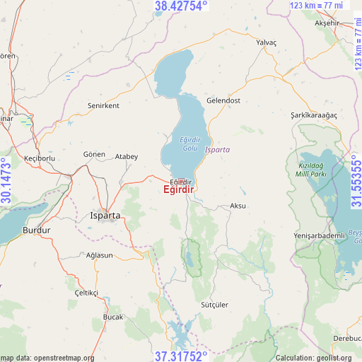
Eğirdir GPS coordinates[2]
37° 52' 28.632" North, 30° 51' 1.512" East
| Map corner | latitude | longitude |
|---|---|---|
| Upper-left | 38.42754°, | 30.1473° |
| Center: | 37.87462°, | 30.85042° |
| Lower-right: | 37.31752°, | 31.55355° |
| Map W x H: | 123.4×123.4 km | = 76.7×76.7mi |
| max Lat: | 42.02683° ⇑66.1% North |
| Eğirdir: | 37.87462° |
| min Lat: | ⇓33.9% South 35.9025° |
| min Long | Eğirdir | max Long |
| 25.90902° | 30.85042° | 44.60099° |
| W 28.8%⇐ | ⇒71.2% E |
Elevation
Elevation of Eğirdir is 925 m = 3035 ft, and this is 207.6 m = 681 ft above average elevation for this country.
| Max E: |
2682 m = 8799 ft | 37.4% |
| Eğirdir | 925 m 3035 ft | |
| Avg. | 717.4 m = 2354 ft | |
Min E: |
0 m = 0 ft | 62.6% |
See also: Turkey elevation on elevation.city.
Geographical zone
Eğirdir is located in North temperate zone (between Tropic of Cancer and the Arctic Circle). Distance of this Northern Tropic circle is 1605.3 km =997.5 mi to South.| Distance of | km | miles | from Eğirdir |
|---|---|---|---|
| North Pole | 5795.8 | 3601.3 | to North |
| Arctic Circle | 3189.9 | 1982.1 | to North |
| Tropic Cancer | 1605.3 | 997.5 | to South |
| Equator | 4211.3 | 2616.8 | to South |


Nearby cities:
15 places around Eğirdir: (largest is in red/bold)
• Aksu
21.1 km =13.1 mi,  113°
113°
• Anamas
12.8 km =8 mi,  200°
200°
• Atabey
20.4 km =12.7 mi,  294°
294°
• Ağlasun
37.4 km =23.2 mi,  227°
227°
• Barla
17 km =10.6 mi,  339°
339°
• Gelendost
31 km =19.3 mi,  27°
27°
• Gönen
31.1 km =19.3 mi, 286°
• Isparta
28.9 km =18 mi,  244°
244°
• Kasımlar
48.8 km =30.3 mi,  141°
141°
• Keçiborlu
48.7 km =30.3 mi,  278°
278°
• Pavlu Cebel
43.4 km =27 mi,  165°
165°
• Senirkent
36.8 km =22.9 mi,  314°
314°
• Uluborlu
41.8 km =26 mi,  302°
302°
• Çeltikçi
50.3 km =31.3 mi,  220°
220°
• Şarkîkaraağaç
50.6 km =31.4 mi,  63°
63°
Sources, notices
• [Note1] Compared only with cities in Turkey existing in our database
• [Src1] Map data: © OpenStreetMap contributors (CC-BY-SA)
• [Src2] Other city data from geonames.org with taken over terms of usage.
• [Src3] Geographical zone / Annual Mean Temperature by Robert A. Rohde @ Wikipedia
