Gelendost geodata
Gelendost (Isparta) is a seat of a second-order administrative division; located in Turkey in Europe/Istanbul (GMT+3) time zone. With population of 7,274 people, there are 605 cities with bigger population in this country. Compared to other cities in Turkey, 59.3% of cities are located further ↑North; 70.5% of cities are located further →East and 64.5% of cities have lower elevation than Gelendost. Note1


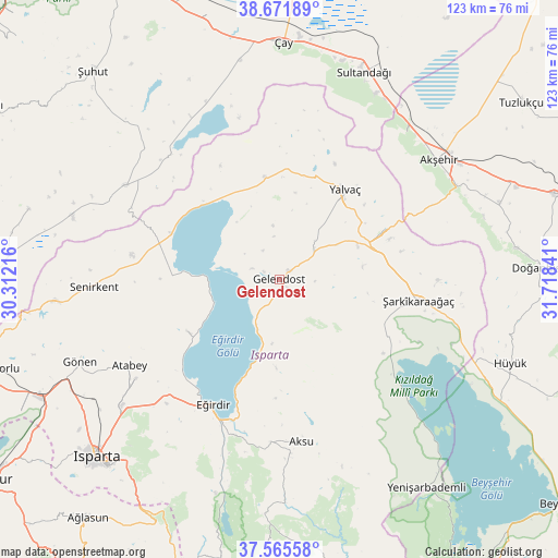
Gelendost GPS coordinates[2]
38° 7' 14.988" North, 31° 0' 55.008" East
| Map corner | latitude | longitude |
|---|---|---|
| Upper-left | 38.67189°, | 30.31216° |
| Center: | 38.12083°, | 31.01528° |
| Lower-right: | 37.56558°, | 31.71841° |
| Map W x H: | 123×123 km | = 76.4×76.4mi |
| max Lat: | 42.02683° ⇑59.3% North |
| Gelendost: | 38.12083° |
| min Lat: | ⇓40.7% South 35.9025° |
| min Long | Gelendost | max Long |
| 25.90902° | 31.01528° | 44.60099° |
| W 29.5%⇐ | ⇒70.5% E |
Elevation
Elevation of Gelendost is 951 m = 3120 ft, and this is 233.6 m = 766 ft above average elevation for this country.
| Max E: |
2682 m = 8799 ft | 35.5% |
| Gelendost | 951 m 3120 ft | |
| Avg. | 717.4 m = 2354 ft | |
Min E: |
0 m = 0 ft | 64.5% |
See also: Turkey elevation on elevation.city.
Geographical zone
Gelendost is located in North temperate zone (between Tropic of Cancer and the Arctic Circle). Distance of this Northern Tropic circle is 1632.7 km =1014.5 mi to South.| Distance of | km | miles | from Gelendost |
|---|---|---|---|
| North Pole | 5768.4 | 3584.3 | to North |
| Arctic Circle | 3162.5 | 1965.1 | to North |
| Tropic Cancer | 1632.7 | 1014.5 | to South |
| Equator | 4238.6 | 2633.7 | to South |


Nearby cities:
15 places around Gelendost: (largest is in red/bold)
• Aksu
36.1 km =22.4 mi,  172°
172°
• Akşehir
43.8 km =27.2 mi,  53°
53°
• Anamas
43.7 km =27.2 mi,  205°
205°
• Atabey
38 km =23.6 mi,  240°
240°
• Barla
23.4 km =14.5 mi, 240°
• Bağkonak
24.9 km =15.5 mi,  64°
64°
• Eğirdir
31 km =19.3 mi, 207°
• Gönen
47.8 km =29.7 mi,  247°
247°
• Kumdanlı
22.8 km =14.2 mi,  351°
351°
• Reis
51.4 km =31.9 mi,  70°
70°
• Senirkent
40.9 km =25.4 mi,  267°
267°
• Sultandağı
49.2 km =30.6 mi,  22°
22°
• Uluborlu
49.7 km =30.9 mi,  264°
264°
• Yalvaç
24.1 km =15 mi,  36°
36°
• Şarkîkaraağaç
31.1 km =19.3 mi,  98°
98°
Sources, notices
• [Note1] Compared only with cities in Turkey existing in our database
• [Src1] Map data: © OpenStreetMap contributors (CC-BY-SA)
• [Src2] Other city data from geonames.org with taken over terms of usage.
• [Src3] Geographical zone / Annual Mean Temperature by Robert A. Rohde @ Wikipedia
