Sandıklı geodata
Sandıklı (Afyonkarahisar) is a seat of a second-order administrative division; located in Turkey in Europe/Istanbul (GMT+3) time zone. With population of 42,981 people, there are 199 cities with bigger population in this country. Compared to other cities in Turkey, 53.3% of cities are located further ↑North; 74.4% of cities are located further →East and 73.8% of cities have lower elevation than Sandıklı. Note1


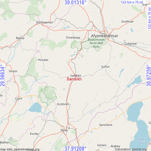
Sandıklı GPS coordinates[2]
38° 27' 52.992" North, 30° 16' 10.056" East
| Map corner | latitude | longitude |
|---|---|---|
| Upper-left | 39.01316°, | 29.56634° |
| Center: | 38.46472°, | 30.26946° |
| Lower-right: | 37.91208°, | 30.97259° |
| Map W x H: | 122.4×122.4 km | = 76.1×76.1mi |
| max Lat: | 42.02683° ⇑53.3% North |
| Sandıklı: | 38.46472° |
| min Lat: | ⇓46.7% South 35.9025° |
| min Long | Sandıklı | max Long |
| 25.90902° | 30.26946° | 44.60099° |
| W 25.6%⇐ | ⇒74.4% E |
Elevation
Elevation of Sandıklı is 1086 m = 3563 ft, and this is 368.6 m = 1209 ft above average elevation for this country.
| Max E: |
2682 m = 8799 ft | 26.2% |
| Sandıklı | 1086 m 3563 ft | |
| Avg. | 717.4 m = 2354 ft | |
Min E: |
0 m = 0 ft | 73.8% |
See also: Sandıklı elevation on elevation.city.
Geographical zone
Sandıklı is located in North temperate zone (between Tropic of Cancer and the Arctic Circle). Distance of this Northern Tropic circle is 1671 km =1038.3 mi to South.| Distance of | km | miles | from Sandıklı |
|---|---|---|---|
| North Pole | 5730.2 | 3560.6 | to North |
| Arctic Circle | 3124.3 | 1941.3 | to North |
| Tropic Cancer | 1671 | 1038.3 | to South |
| Equator | 4276.9 | 2657.5 | to South |


Nearby cities:
15 places around Sandıklı: (largest is in red/bold)
• Afyonkarahisar
40.2 km =25 mi,  36°
36°
• Dinar
45.4 km =28.2 mi,  191°
191°
• Dombay
34.9 km =21.7 mi, 188°
• Haydarlı
24.9 km =15.5 mi,  156°
156°
• Hocalar
29.1 km =18.1 mi,  295°
295°
• Homa
35.2 km =21.9 mi,  224°
224°
• Işıklar
47 km =29.2 mi,  60°
60°
• Karadirek
13.7 km =8.5 mi,  327°
327°
• Kızılören
25.2 km =15.7 mi,  204°
204°
• Senirkent
46.9 km =29.1 mi,  148°
148°
• Sinanpaşa
31.2 km =19.4 mi,  355°
355°
• Uluborlu
45.8 km =28.5 mi, 159°
• Çivril
49.7 km =30.9 mi,  248°
248°
• İshaklı
37 km =23 mi, 217°
• Şuhut
25.2 km =15.7 mi,  72°
72°
Sources, notices
• [Note1] Compared only with cities in Turkey existing in our database
• [Src1] Map data: © OpenStreetMap contributors (CC-BY-SA)
• [Src2] Other city data from geonames.org with taken over terms of usage.
• [Src3] Geographical zone / Annual Mean Temperature by Robert A. Rohde @ Wikipedia
