Pazarlar geodata
Pazarlar (Kütahya) is a seat of a second-order administrative division; located in Turkey in Europe/Istanbul (GMT+3) time zone. With population of 6,387 people, there are 637 cities with bigger population in this country. Compared to other cities in Turkey, 54.4% of cities are located further ↓South; 82.6% of cities are located further →East and 63.6% of cities have lower elevation than Pazarlar. Note1


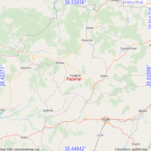
Pazarlar GPS coordinates[2]
38° 59' 42" North, 29° 7' 32.988" East
| Map corner | latitude | longitude |
|---|---|---|
| Upper-left | 39.53936°, | 28.42271° |
| Center: | 38.995°, | 29.12583° |
| Lower-right: | 38.44642°, | 29.82896° |
| Map W x H: | 121.5×121.5 km | = 75.5×75.5mi |
| max Lat: | 42.02683° ⇑45.6% North |
| Pazarlar: | 38.995° |
| min Lat: | ⇓54.4% South 35.9025° |
| min Long | Pazarlar | max Long |
| 25.90902° | 29.12583° | 44.60099° |
| W 17.4%⇐ | ⇒82.6% E |
Elevation
Elevation of Pazarlar is 936 m = 3071 ft, and this is 218.6 m = 717 ft above average elevation for this country.
| Max E: |
2682 m = 8799 ft | 36.4% |
| Pazarlar | 936 m 3071 ft | |
| Avg. | 717.4 m = 2354 ft | |
Min E: |
0 m = 0 ft | 63.6% |
See also: Turkey elevation on elevation.city.
Geographical zone
Pazarlar is located in North temperate zone (between Tropic of Cancer and the Arctic Circle). Distance of this Northern Tropic circle is 1729.9 km =1074.9 mi to South.| Distance of | km | miles | from Pazarlar |
|---|---|---|---|
| North Pole | 5671.2 | 3523.9 | to North |
| Arctic Circle | 3065.3 | 1904.7 | to North |
| Tropic Cancer | 1729.9 | 1074.9 | to South |
| Equator | 4335.8 | 2694.1 | to South |


Nearby cities:
15 places around Pazarlar: (largest is in red/bold)
• Bölme
46.8 km =29.1 mi,  152°
152°
• Dağardı
49.7 km =30.9 mi,  346°
346°
• Demirci
40.7 km =25.3 mi,  278°
278°
• Emet
40.3 km =25 mi,  16°
16°
• Gediz
22.9 km =14.2 mi,  90°
90°
• Güre
38.4 km =23.9 mi,  174°
174°
• Hisarcık
29.8 km =18.5 mi, 17°
• Selendi
35.7 km =22.2 mi,  218°
218°
• Simav
16.5 km =10.3 mi,  309°
309°
• Uşak
43.2 km =26.8 mi, 145°
• Yarbasan
27.5 km =17.1 mi,  268°
268°
• Çavdarhisar
47.9 km =29.8 mi,  62°
62°
• Örencik
46.7 km =29 mi,  50°
50°
• İlyaslı
44 km =27.3 mi, 171°
• Şaphane
9.1 km =5.7 mi,  66°
66°
Sources, notices
• [Note1] Compared only with cities in Turkey existing in our database
• [Src1] Map data: © OpenStreetMap contributors (CC-BY-SA)
• [Src2] Other city data from geonames.org with taken over terms of usage.
• [Src3] Geographical zone / Annual Mean Temperature by Robert A. Rohde @ Wikipedia
