Simav geodata
Simav (Kütahya) is a seat of a second-order administrative division; located in Turkey in Europe/Istanbul (GMT+3) time zone. With population of 34,909 people, there are 227 cities with bigger population in this country. Compared to other cities in Turkey, 55.8% of cities are located further ↓South; 84.1% of cities are located further →East and 56.9% of cities have lower elevation than Simav. Note1


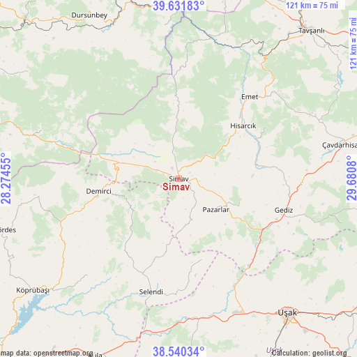
Simav GPS coordinates[2]
39° 5' 17.52" North, 28° 58' 39.612" East
| Map corner | latitude | longitude |
|---|---|---|
| Upper-left | 39.63183°, | 28.27455° |
| Center: | 39.0882°, | 28.97767° |
| Lower-right: | 38.54034°, | 29.6808° |
| Map W x H: | 121.4×121.4 km | = 75.4×75.4mi |
| max Lat: | 42.02683° ⇑44.2% North |
| Simav: | 39.0882° |
| min Lat: | ⇓55.8% South 35.9025° |
| min Long | Simav | max Long |
| 25.90902° | 28.97767° | 44.60099° |
| W 15.9%⇐ | ⇒84.1% E |
Elevation
Elevation of Simav is 826 m = 2710 ft, and this is 108.6 m = 356 ft above average elevation for this country.
| Max E: |
2682 m = 8799 ft | 43.1% |
| Simav | 826 m 2710 ft | |
| Avg. | 717.4 m = 2354 ft | |
Min E: |
0 m = 0 ft | 56.9% |
See also: Turkey elevation on elevation.city.
Geographical zone
Simav is located in North temperate zone (between Tropic of Cancer and the Arctic Circle). Distance of this Northern Tropic circle is 1740.3 km =1081.4 mi to South.| Distance of | km | miles | from Simav |
|---|---|---|---|
| North Pole | 5660.9 | 3517.5 | to North |
| Arctic Circle | 3055 | 1898.3 | to North |
| Tropic Cancer | 1740.3 | 1081.4 | to South |
| Equator | 4346.2 | 2700.6 | to South |


Nearby cities:
15 places around Simav: (largest is in red/bold)
• Dağardı
38.1 km =23.7 mi,  2°
2°
• Demirci
27.9 km =17.3 mi,  260°
260°
• Düvertepe
49.2 km =30.6 mi,  289°
289°
• Emet
37.3 km =23.2 mi,  40°
40°
• Gediz
37.2 km =23.1 mi,  106°
106°
• Gökçedağ
52.5 km =32.6 mi,  354°
354°
• Güre
51.3 km =31.9 mi,  161°
161°
• Hisarcık
28.3 km =17.6 mi,  50°
50°
• Pazarlar
16.5 km =10.3 mi,  129°
129°
• Selendi
39.4 km =24.5 mi,  193°
193°
• Yarbasan
18.3 km =11.4 mi,  232°
232°
• Çavdarhisar
56.5 km =35.1 mi,  78°
78°
• Örencik
52.5 km =32.6 mi,  68°
68°
• İlyaslı
57.2 km =35.5 mi, 160°
• Şaphane
22.2 km =13.8 mi, 107°
Sources, notices
• [Note1] Compared only with cities in Turkey existing in our database
• [Src1] Map data: © OpenStreetMap contributors (CC-BY-SA)
• [Src2] Other city data from geonames.org with taken over terms of usage.
• [Src3] Geographical zone / Annual Mean Temperature by Robert A. Rohde @ Wikipedia
