Emet geodata
Emet (Kütahya) is a seat of a second-order administrative division; located in Turkey in Europe/Istanbul (GMT+3) time zone. With population of 23,812 people, there are 298 cities with bigger population in this country. Compared to other cities in Turkey, 59.4% of cities are located further ↓South; 81.4% of cities are located further →East and 60.7% of cities have lower elevation than Emet. Note1


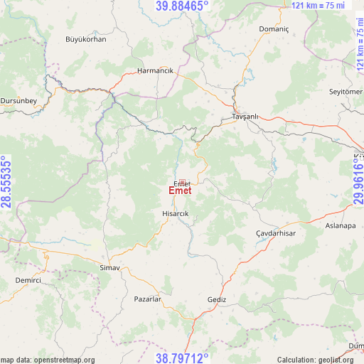
Emet GPS coordinates[2]
39° 20' 34.8" North, 29° 15' 30.492" East
| Map corner | latitude | longitude |
|---|---|---|
| Upper-left | 39.88465°, | 28.55535° |
| Center: | 39.343°, | 29.25847° |
| Lower-right: | 38.79712°, | 29.9616° |
| Map W x H: | 120.9×120.9 km | = 75.1×75.1mi |
| max Lat: | 42.02683° ⇑40.6% North |
| Emet: | 39.343° |
| min Lat: | ⇓59.4% South 35.9025° |
| min Long | Emet | max Long |
| 25.90902° | 29.25847° | 44.60099° |
| W 18.6%⇐ | ⇒81.4% E |
Elevation
Elevation of Emet is 895 m = 2936 ft, and this is 177.6 m = 583 ft above average elevation for this country.
| Max E: |
2682 m = 8799 ft | 39.3% |
| Emet | 895 m 2936 ft | |
| Avg. | 717.4 m = 2354 ft | |
Min E: |
0 m = 0 ft | 60.7% |
See also: Turkey elevation on elevation.city.
Geographical zone
Emet is located in North temperate zone (between Tropic of Cancer and the Arctic Circle). Distance of this Northern Tropic circle is 1768.6 km =1099 mi to South.| Distance of | km | miles | from Emet |
|---|---|---|---|
| North Pole | 5632.5 | 3499.9 | to North |
| Arctic Circle | 3026.6 | 1880.6 | to North |
| Tropic Cancer | 1768.6 | 1099 | to South |
| Equator | 4374.5 | 2718.2 | to South |


Nearby cities:
15 places around Emet: (largest is in red/bold)
• Aslanapa
54.5 km =33.9 mi,  105°
105°
• Dağardı
24.6 km =15.3 mi,  293°
293°
• Gediz
40.5 km =25.2 mi,  163°
163°
• Gökçedağ
37.7 km =23.4 mi,  309°
309°
• Harmancık
38.1 km =23.7 mi,  346°
346°
• Hisarcık
10.5 km =6.5 mi,  192°
192°
• Köprüören
47 km =29.2 mi,  66°
66°
• Pazarlar
40.3 km =25 mi,  196°
196°
• Simav
37.3 km =23.2 mi,  220°
220°
• Tavşanlı
30.3 km =18.8 mi,  42°
42°
• Yarbasan
55.3 km =34.4 mi, 224°
• Yenice
55.4 km =34.4 mi,  327°
327°
• Çavdarhisar
35.2 km =21.9 mi,  118°
118°
• Örencik
26.1 km =16.2 mi, 110°
• Şaphane
35.2 km =21.9 mi, 185°
Sources, notices
• [Note1] Compared only with cities in Turkey existing in our database
• [Src1] Map data: © OpenStreetMap contributors (CC-BY-SA)
• [Src2] Other city data from geonames.org with taken over terms of usage.
• [Src3] Geographical zone / Annual Mean Temperature by Robert A. Rohde @ Wikipedia
