Selendi geodata
Selendi (Manisa) is a seat of a second-order administrative division; located in Turkey in Europe/Istanbul (GMT+3) time zone. With population of 8,735 people, there are 542 cities with bigger population in this country. Compared to other cities in Turkey, 50.9% of cities are located further ↓South; 85% of cities are located further →East and 63.5% of cities have higher elevation than Selendi. Note1


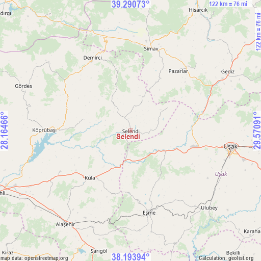
Selendi GPS coordinates[2]
38° 44' 39.984" North, 28° 52' 4.008" East
| Map corner | latitude | longitude |
|---|---|---|
| Upper-left | 39.29073°, | 28.16466° |
| Center: | 38.74444°, | 28.86778° |
| Lower-right: | 38.19394°, | 29.57091° |
| Map W x H: | 122×122 km | = 75.8×75.8mi |
| max Lat: | 42.02683° ⇑49.1% North |
| Selendi: | 38.74444° |
| min Lat: | ⇓50.9% South 35.9025° |
| min Long | Selendi | max Long |
| 25.90902° | 28.86778° | 44.60099° |
| W 15%⇐ | ⇒85% E |
Elevation
Elevation of Selendi is 443 m = 1453 ft, and this is 274.4 m = 900 ft below average elevation for this country.
| Max E: |
2682 m = 8799 ft | 63.5% |
| Avg. | 717.4 m = 2354 ft | |
| Selendi | 443 m = 1453 ft | |
Min E: |
0 m = 0 ft | 36.5% |
See also: Turkey elevation on elevation.city.
Geographical zone
Selendi is located in North temperate zone (between Tropic of Cancer and the Arctic Circle). Distance of this Northern Tropic circle is 1702.1 km =1057.6 mi to South.| Distance of | km | miles | from Selendi |
|---|---|---|---|
| North Pole | 5699.1 | 3541.3 | to North |
| Arctic Circle | 3093.2 | 1922 | to North |
| Tropic Cancer | 1702.1 | 1057.6 | to South |
| Equator | 4308 | 2676.9 | to South |


Nearby cities:
15 places around Selendi: (largest is in red/bold)
• Borlu
34.7 km =21.6 mi,  271°
271°
• Bölme
46 km =28.6 mi,  107°
107°
• Demirci
38.1 km =23.7 mi,  331°
331°
• Eşme
39.3 km =24.4 mi,  167°
167°
• Güre
28 km =17.4 mi, 111°
• Kula
29 km =18 mi,  220°
220°
• Köprübaşı
40.2 km =25 mi, 270°
• Menye
37.9 km =23.5 mi,  240°
240°
• Pazarlar
35.7 km =22.2 mi,  38°
38°
• Simav
39.4 km =24.5 mi,  13°
13°
• Uşak
47.3 km =29.4 mi,  99°
99°
• Yarbasan
27.7 km =17.2 mi,  349°
349°
• Yeşilyurt
48.4 km =30.1 mi,  201°
201°
• İlyaslı
32.8 km =20.4 mi,  118°
118°
• Şaphane
43.9 km =27.3 mi, 44°
Sources, notices
• [Note1] Compared only with cities in Turkey existing in our database
• [Src1] Map data: © OpenStreetMap contributors (CC-BY-SA)
• [Src2] Other city data from geonames.org with taken over terms of usage.
• [Src3] Geographical zone / Annual Mean Temperature by Robert A. Rohde @ Wikipedia
