Boğazkale geodata
Boğazkale (Çorum) is a seat of a second-order administrative division; located in Turkey in Europe/Istanbul (GMT+3) time zone. In our database, there are 1323 cities with bigger population. Compared to other cities in Turkey, 69.5% of cities are located further ↓South; 56% of cities are located further →East and 69% of cities have lower elevation than Boğazkale. Note1


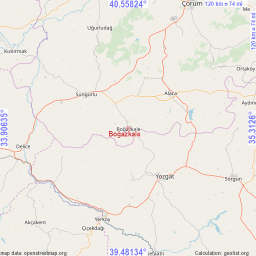
Boğazkale GPS coordinates[2]
40° 1' 18.876" North, 34° 36' 34.092" East
| Map corner | latitude | longitude |
|---|---|---|
| Upper-left | 40.55824°, | 33.90635° |
| Center: | 40.02191°, | 34.60947° |
| Lower-right: | 39.48134°, | 35.3126° |
| Map W x H: | 119.7×119.7 km | = 74.4×74.4mi |
| max Lat: | 42.02683° ⇑30.5% North |
| Boğazkale: | 40.02191° |
| min Lat: | ⇓69.5% South 35.9025° |
| min Long | Boğazkale | max Long |
| 25.90902° | 34.60947° | 44.60099° |
| W 44%⇐ | ⇒56% E |
Elevation
Elevation of Boğazkale is 1013 m = 3323 ft, and this is 295.6 m = 970 ft above average elevation for this country.
| Max E: |
2682 m = 8799 ft | 31% |
| Boğazkale | 1013 m 3323 ft | |
| Avg. | 717.4 m = 2354 ft | |
Min E: |
0 m = 0 ft | 69% |
See also: Turkey elevation on elevation.city.
Geographical zone
Boğazkale is located in North temperate zone (between Tropic of Cancer and the Arctic Circle). Distance of this Northern Tropic circle is 1844.1 km =1145.9 mi to South.| Distance of | km | miles | from Boğazkale |
|---|---|---|---|
| North Pole | 5557 | 3453 | to North |
| Arctic Circle | 2951.2 | 1833.8 | to North |
| Tropic Cancer | 1844.1 | 1145.9 | to South |
| Equator | 4450 | 2765.1 | to South |


Nearby cities:
15 places around Boğazkale: (largest is in red/bold)
• Alaca
25.6 km =15.9 mi,  50°
50°
• Aydıncık
58.9 km =36.6 mi,  78°
78°
• Cemilbey
52 km =32.3 mi, 46°
• Delice
50.3 km =31.3 mi,  261°
261°
• Eymir
51 km =31.7 mi,  90°
90°
• Musabeyli
21 km =13 mi,  176°
176°
• Osmanpaşa
53.6 km =33.3 mi,  145°
145°
• Salmanlı
33 km =20.5 mi,  246°
246°
• Sorgun
54.5 km =33.9 mi,  115°
115°
• Sungurlu
25.8 km =16 mi,  308°
308°
• Uğurludağ
49 km =30.4 mi,  344°
344°
• Yerköy
44.4 km =27.6 mi,  195°
195°
• Yozgat
27.9 km =17.3 mi,  143°
143°
• Çiçekdağı
49.2 km =30.6 mi, 200°
• Şefaatlı
58.9 km =36.6 mi,  167°
167°
In other languages:
- In Spanish: Hattusas
- In France: Hattousa
- In German: Hattuša
- In Italian: Hattusa
- In Russian: Хаттуса
Sources, notices
• [Note1] Compared only with cities in Turkey existing in our database
• [Src1] Map data: © OpenStreetMap contributors (CC-BY-SA)
• [Src2] Other city data from geonames.org with taken over terms of usage.
• [Src3] Geographical zone / Annual Mean Temperature by Robert A. Rohde @ Wikipedia
