Çiçekdağı geodata
Çiçekdağı (Kırşehir) is a seat of a second-order administrative division; located in Turkey in Europe/Istanbul (GMT+3) time zone. In our database, there are 1323 cities with bigger population. Compared to other cities in Turkey, 63.1% of cities are located further ↓South; 56.9% of cities are located further →East and 65% of cities have lower elevation than Çiçekdağı. Note1


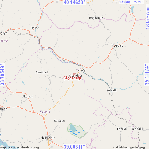
Çiçekdağı GPS coordinates[2]
39° 36' 24.984" North, 34° 24' 30.996" East
| Map corner | latitude | longitude |
|---|---|---|
| Upper-left | 40.14653°, | 33.70549° |
| Center: | 39.60694°, | 34.40861° |
| Lower-right: | 39.06311°, | 35.11174° |
| Map W x H: | 120.5×120.5 km | = 74.9×74.9mi |
| max Lat: | 42.02683° ⇑36.9% North |
| Çiçekdağı: | 39.60694° |
| min Lat: | ⇓63.1% South 35.9025° |
| min Long | Çiçekdağı | max Long |
| 25.90902° | 34.40861° | 44.60099° |
| W 43.1%⇐ | ⇒56.9% E |
Elevation
Elevation of Çiçekdağı is 957 m = 3140 ft, and this is 239.6 m = 786 ft above average elevation for this country.
| Max E: |
2682 m = 8799 ft | 35% |
| Çiçekdağı | 957 m 3140 ft | |
| Avg. | 717.4 m = 2354 ft | |
Min E: |
0 m = 0 ft | 65% |
See also: Turkey elevation on elevation.city.
Geographical zone
Çiçekdağı is located in North temperate zone (between Tropic of Cancer and the Arctic Circle). Distance of this Northern Tropic circle is 1798 km =1117.2 mi to South.| Distance of | km | miles | from Çiçekdağı |
|---|---|---|---|
| North Pole | 5603.2 | 3481.7 | to North |
| Arctic Circle | 2997.3 | 1862.4 | to North |
| Tropic Cancer | 1798 | 1117.2 | to South |
| Equator | 4403.9 | 2736.5 | to South |


Nearby cities:
15 places around Çiçekdağı: (largest is in red/bold)
• Akpınar
41.9 km =26 mi,  245°
245°
• Akçakent
26.8 km =16.7 mi,  273°
273°
• Boztepe
39.6 km =24.6 mi,  198°
198°
• Boğazkale
49.2 km =30.6 mi,  20°
20°
• Delice
50.6 km =31.4 mi,  319°
319°
• Göllü
19.8 km =12.3 mi,  208°
208°
• Karahasanlı
43.7 km =27.2 mi,  142°
142°
• Kösefakılı
23.4 km =14.5 mi, 266°
• Kırşehir
55.4 km =34.4 mi, 202°
• Musabeyli
31.1 km =19.3 mi,  36°
36°
• Osmanpaşa
47.7 km =29.6 mi,  87°
87°
• Salmanlı
35.4 km =22 mi,  338°
338°
• Yerköy
6.1 km =3.8 mi,  55°
55°
• Yozgat
41.3 km =25.7 mi, 55°
• Şefaatlı
31.9 km =19.8 mi,  110°
110°
Sources, notices
• [Note1] Compared only with cities in Turkey existing in our database
• [Src1] Map data: © OpenStreetMap contributors (CC-BY-SA)
• [Src2] Other city data from geonames.org with taken over terms of usage.
• [Src3] Geographical zone / Annual Mean Temperature by Robert A. Rohde @ Wikipedia
