Osmaniye geodata
Osmaniye is a seat of a first-order administrative division; located in Turkey in Europe/Istanbul (GMT+3) time zone. With population of 202,837 people, there are 49 cities with bigger population in this country. Compared to other cities in Turkey, 86.7% of cities are located further ↑North; 53% of cities are located further ←West and 78.7% of cities have higher elevation than Osmaniye. Note1


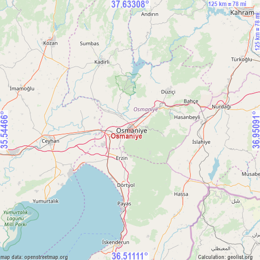
Osmaniye GPS coordinates[2]
37° 4' 27.012" North, 36° 14' 52.008" East
| Map corner | latitude | longitude |
|---|---|---|
| Upper-left | 37.63308°, | 35.54466° |
| Center: | 37.07417°, | 36.24778° |
| Lower-right: | 36.51111°, | 36.95091° |
| Map W x H: | 124.8×124.8 km | = 77.5×77.5mi |
| max Lat: | 42.02683° ⇑86.7% North |
| Osmaniye: | 37.07417° |
| min Lat: | ⇓13.3% South 35.9025° |
| min Long | Osmaniye | max Long |
| 25.90902° | 36.24778° | 44.60099° |
| W 53%⇐ | ⇒47% E |
Elevation
Elevation of Osmaniye is 128 m = 420 ft, and this is 589.4 m = 1934 ft below average elevation for this country.
| Max E: |
2682 m = 8799 ft | 78.7% |
| Avg. | 717.4 m = 2354 ft | |
| Osmaniye | 128 m = 420 ft | |
Min E: |
0 m = 0 ft | 21.3% |
See also: Osmaniye elevation on elevation.city.
Geographical zone
Osmaniye is located in North temperate zone (between Tropic of Cancer and the Arctic Circle). Distance of this Northern Tropic circle is 1516.3 km =942.2 mi to South.| Distance of | km | miles | from Osmaniye |
|---|---|---|---|
| North Pole | 5884.8 | 3656.6 | to North |
| Arctic Circle | 3278.9 | 2037.4 | to North |
| Tropic Cancer | 1516.3 | 942.2 | to South |
| Equator | 4122.3 | 2561.5 | to South |


Nearby cities:
15 places around Osmaniye: (largest is in red/bold)
• Bahçe
32.2 km =20 mi,  64°
64°
• Dörtyol
26.2 km =16.3 mi,  183°
183°
• Erzin
14.1 km =8.8 mi,  198°
198°
• Fevzipaşa
34.6 km =21.5 mi,  86°
86°
• Haruniye
26.2 km =16.3 mi,  44°
44°
• Hasanbeyli
27.1 km =16.8 mi,  77°
77°
• Kaypak
19.8 km =12.3 mi, 76°
• Konaklı
30 km =18.6 mi,  173°
173°
• Kösreli
25.8 km =16 mi,  292°
292°
• Mahmutlar
14.8 km =9.2 mi, 199°
• Payas
35.5 km =22.1 mi, 184°
• Tecirli
15.6 km =9.7 mi,  308°
308°
• Toprakkale
9 km =5.6 mi,  266°
266°
• Yarpuz
16.5 km =10.3 mi,  100°
100°
• İslahiye
34.4 km =21.4 mi, 99°
Sources, notices
• [Note1] Compared only with cities in Turkey existing in our database
• [Src1] Map data: © OpenStreetMap contributors (CC-BY-SA)
• [Src2] Other city data from geonames.org with taken over terms of usage.
• [Src3] Geographical zone / Annual Mean Temperature by Robert A. Rohde @ Wikipedia
