Konaklı geodata
Konaklı (Hatay) is a populated place; located in Turkey in Europe/Istanbul (GMT+3) time zone. With population of 771 people, there are 1167 cities with bigger population in this country. Compared to other cities in Turkey, 93.1% of cities are located further ↑North; 53.3% of cities are located further ←West and 59.9% of cities have higher elevation than Konaklı. Note1


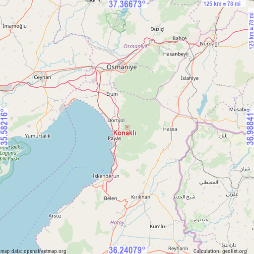
Konaklı GPS coordinates[2]
36° 48' 20.988" North, 36° 17' 7.008" East
| Map corner | latitude | longitude |
|---|---|---|
| Upper-left | 37.36673°, | 35.58216° |
| Center: | 36.80583°, | 36.28528° |
| Lower-right: | 36.24079°, | 36.98841° |
| Map W x H: | 125.2×125.2 km | = 77.8×77.8mi |
| max Lat: | 42.02683° ⇑93.1% North |
| Konaklı: | 36.80583° |
| min Lat: | ⇓6.9% South 35.9025° |
| min Long | Konaklı | max Long |
| 25.90902° | 36.28528° | 44.60099° |
| W 53.3%⇐ | ⇒46.7% E |
Elevation
Elevation of Konaklı is 508 m = 1667 ft, and this is 209.4 m = 687 ft below average elevation for this country.
| Max E: |
2682 m = 8799 ft | 59.9% |
| Avg. | 717.4 m = 2354 ft | |
| Konaklı | 508 m = 1667 ft | |
Min E: |
0 m = 0 ft | 40.1% |
See also: Turkey elevation on elevation.city.
Geographical zone
Konaklı is located in North temperate zone (between Tropic of Cancer and the Arctic Circle). Distance of this Northern Tropic circle is 1486.5 km =923.7 mi to South.| Distance of | km | miles | from Konaklı |
|---|---|---|---|
| North Pole | 5914.6 | 3675.2 | to North |
| Arctic Circle | 3308.7 | 2055.9 | to North |
| Tropic Cancer | 1486.5 | 923.7 | to South |
| Equator | 4092.4 | 2542.9 | to South |


Nearby cities:
15 places around Konaklı: (largest is in red/bold)
• Aktepe
21.3 km =13.2 mi,  123°
123°
• Aşağı Karafakılı
24.4 km =15.2 mi,  97°
97°
• Balarmudu
21 km =13 mi,  148°
148°
• Denizciler
19.4 km =12.1 mi,  199°
199°
• Dörtyol
6.1 km =3.8 mi,  307°
307°
• Erzin
18.1 km =11.2 mi,  334°
334°
• Gyuvench
18.2 km =11.3 mi,  137°
137°
• Hassa
20.7 km =12.9 mi,  91°
91°
• Mahmutlar
17.9 km =11.1 mi, 332°
• Osmaniye
30 km =18.6 mi,  353°
353°
• Payas
8.4 km =5.2 mi,  228°
228°
• Toprakkale
31.7 km =19.7 mi,  337°
337°
• Yalangöz
32.3 km =20.1 mi, 142°
• Yarpuz
29.9 km =18.6 mi,  25°
25°
• İskenderun
26.3 km =16.3 mi, 202°
Sources, notices
• [Note1] Compared only with cities in Turkey existing in our database
• [Src1] Map data: © OpenStreetMap contributors (CC-BY-SA)
• [Src2] Other city data from geonames.org with taken over terms of usage.
• [Src3] Geographical zone / Annual Mean Temperature by Robert A. Rohde @ Wikipedia
