Bahçe geodata
Bahçe (Adana) is a populated place; located in Turkey in Europe/Istanbul (GMT+3) time zone. With population of 19,566 people, there are 338 cities with bigger population in this country. Compared to other cities in Turkey, 83.4% of cities are located further ↑North; 55.2% of cities are located further ←West and 53.2% of cities have higher elevation than Bahçe. Note1


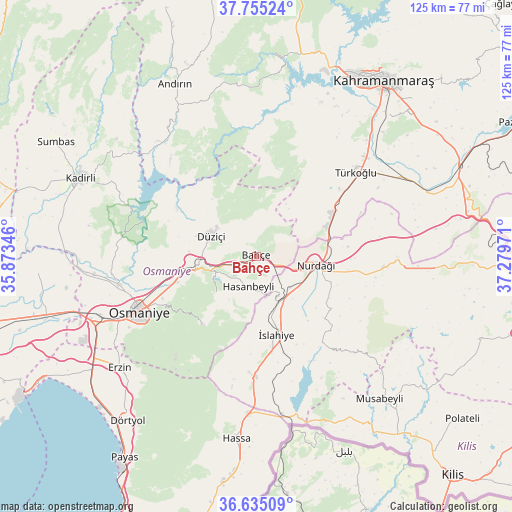
Bahçe GPS coordinates[2]
37° 11' 50.064" North, 36° 34' 35.688" East
| Map corner | latitude | longitude |
|---|---|---|
| Upper-left | 37.75524°, | 35.87346° |
| Center: | 37.19724°, | 36.57658° |
| Lower-right: | 36.63509°, | 37.27971° |
| Map W x H: | 124.5×124.5 km | = 77.4×77.4mi |
| max Lat: | 42.02683° ⇑83.4% North |
| Bahçe: | 37.19724° |
| min Lat: | ⇓16.6% South 35.9025° |
| min Long | Bahçe | max Long |
| 25.90902° | 36.57658° | 44.60099° |
| W 55.2%⇐ | ⇒44.8% E |
Elevation
Elevation of Bahçe is 628 m = 2060 ft, and this is 89.4 m = 293 ft below average elevation for this country.
| Max E: |
2682 m = 8799 ft | 53.2% |
| Avg. | 717.4 m = 2354 ft | |
| Bahçe | 628 m = 2060 ft | |
Min E: |
0 m = 0 ft | 46.8% |
See also: Turkey elevation on elevation.city.
Geographical zone
Bahçe is located in North temperate zone (between Tropic of Cancer and the Arctic Circle). Distance of this Northern Tropic circle is 1530 km =950.7 mi to South.| Distance of | km | miles | from Bahçe |
|---|---|---|---|
| North Pole | 5871.1 | 3648.1 | to North |
| Arctic Circle | 3265.2 | 2028.9 | to North |
| Tropic Cancer | 1530 | 950.7 | to South |
| Equator | 4135.9 | 2569.9 | to South |


Nearby cities:
15 places around Bahçe: (largest is in red/bold)
• Erzin
43.1 km =26.8 mi,  231°
231°
• Fevzipaşa
12.7 km =7.9 mi,  154°
154°
• Haruniye
11.9 km =7.4 mi,  294°
294°
• Hasanbeyli
8.1 km =5 mi,  199°
199°
• Kaypak
13.5 km =8.4 mi, 227°
• Mahmutlar
43.9 km =27.3 mi, 231°
• Nurdağı
14.5 km =9 mi,  102°
102°
• Osmaniye
32.2 km =20 mi,  244°
244°
• Sakçagöz
30.2 km =18.8 mi, 95°
• Tecirli
41.5 km =25.8 mi,  264°
264°
• Toprakkale
40.7 km =25.3 mi,  249°
249°
• Türkoğlu
31.6 km =19.6 mi,  48°
48°
• Yarpuz
21 km =13 mi,  217°
217°
• Yedigöz
43.9 km =27.3 mi, 147°
• İslahiye
19.7 km =12.2 mi,  165°
165°
Sources, notices
• [Note1] Compared only with cities in Turkey existing in our database
• [Src1] Map data: © OpenStreetMap contributors (CC-BY-SA)
• [Src2] Other city data from geonames.org with taken over terms of usage.
• [Src3] Geographical zone / Annual Mean Temperature by Robert A. Rohde @ Wikipedia
