İslahiye geodata
İslahiye (Gaziantep) is a seat of a second-order administrative division; located in Turkey in Europe/Istanbul (GMT+3) time zone. In our database, there are 1323 cities with bigger population. Compared to other cities in Turkey, 87.3% of cities are located further ↑North; 55.4% of cities are located further ←West and 59% of cities have higher elevation than İslahiye. Note1


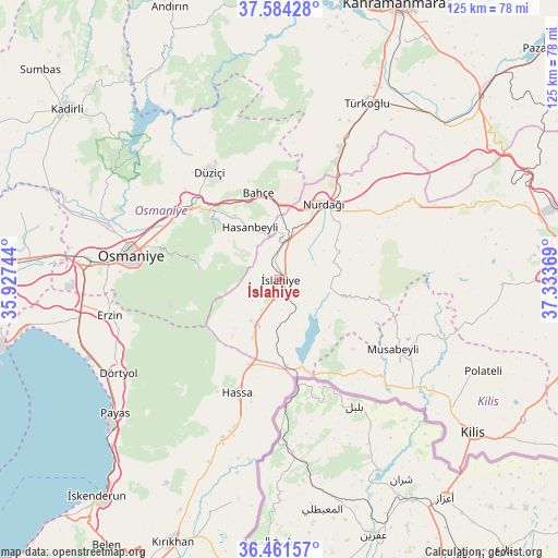
İslahiye GPS coordinates[2]
37° 1' 30" North, 36° 37' 50.016" East
| Map corner | latitude | longitude |
|---|---|---|
| Upper-left | 37.58428°, | 35.92744° |
| Center: | 37.025°, | 36.63056° |
| Lower-right: | 36.46157°, | 37.33369° |
| Map W x H: | 124.8×124.8 km | = 77.5×77.5mi |
| max Lat: | 42.02683° ⇑87.3% North |
| İslahiye: | 37.025° |
| min Lat: | ⇓12.7% South 35.9025° |
| min Long | İslahiye | max Long |
| 25.90902° | 36.63056° | 44.60099° |
| W 55.4%⇐ | ⇒44.6% E |
Elevation
Elevation of İslahiye is 523 m = 1716 ft, and this is 194.4 m = 638 ft below average elevation for this country.
| Max E: |
2682 m = 8799 ft | 59% |
| Avg. | 717.4 m = 2354 ft | |
| İslahiye | 523 m = 1716 ft | |
Min E: |
0 m = 0 ft | 41% |
See also: Turkey elevation on elevation.city.
Geographical zone
İslahiye is located in North temperate zone (between Tropic of Cancer and the Arctic Circle). Distance of this Northern Tropic circle is 1510.9 km =938.8 mi to South.| Distance of | km | miles | from İslahiye |
|---|---|---|---|
| North Pole | 5890.3 | 3660.1 | to North |
| Arctic Circle | 3284.4 | 2040.8 | to North |
| Tropic Cancer | 1510.9 | 938.8 | to South |
| Equator | 4116.8 | 2558.1 | to South |


Nearby cities:
15 places around İslahiye: (largest is in red/bold)
• Aktepe
38.2 km =23.7 mi,  199°
199°
• Aşağı Karafakılı
28.1 km =17.5 mi,  193°
193°
• Bahçe
19.7 km =12.2 mi,  345°
345°
• Fevzipaşa
7.7 km =4.8 mi,  4°
4°
• Haruniye
28.7 km =17.8 mi,  327°
327°
• Hasanbeyli
13.7 km =8.5 mi, 326°
• Hassa
27 km =16.8 mi, 201°
• Kaypak
17.8 km =11.1 mi,  304°
304°
• Konaklı
39.2 km =24.4 mi,  231°
231°
• Musabeyli
29.9 km =18.6 mi,  121°
121°
• Nurdağı
18.5 km =11.5 mi,  30°
30°
• Osmaniye
34.4 km =21.4 mi,  279°
279°
• Sakçagöz
30.1 km =18.7 mi,  57°
57°
• Yarpuz
17.9 km =11.1 mi, 278°
• Yedigöz
26 km =16.2 mi,  132°
132°
Sources, notices
• [Note1] Compared only with cities in Turkey existing in our database
• [Src1] Map data: © OpenStreetMap contributors (CC-BY-SA)
• [Src2] Other city data from geonames.org with taken over terms of usage.
• [Src3] Geographical zone / Annual Mean Temperature by Robert A. Rohde @ Wikipedia
