Haruniye geodata
Haruniye (Osmaniye) is a seat of a second-order administrative division; located in Turkey in Europe/Istanbul (GMT+3) time zone. In our database, there are 1323 cities with bigger population. Compared to other cities in Turkey, 82% of cities are located further ↑North; 54.4% of cities are located further ←West and 66.1% of cities have higher elevation than Haruniye. Note1


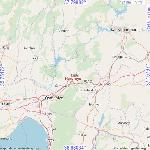
Haruniye GPS coordinates[2]
37° 14' 31.776" North, 36° 27' 17.424" East
| Map corner | latitude | longitude |
|---|---|---|
| Upper-left | 37.79982°, | 35.75172° |
| Center: | 37.24216°, | 36.45484° |
| Lower-right: | 36.68034°, | 37.15797° |
| Map W x H: | 124.5×124.5 km | = 77.4×77.4mi |
| max Lat: | 42.02683° ⇑82% North |
| Haruniye: | 37.24216° |
| min Lat: | ⇓18% South 35.9025° |
| min Long | Haruniye | max Long |
| 25.90902° | 36.45484° | 44.60099° |
| W 54.4%⇐ | ⇒45.6% E |
Elevation
Elevation of Haruniye is 389 m = 1276 ft, and this is 328.4 m = 1077 ft below average elevation for this country.
| Max E: |
2682 m = 8799 ft | 66.1% |
| Avg. | 717.4 m = 2354 ft | |
| Haruniye | 389 m = 1276 ft | |
Min E: |
0 m = 0 ft | 33.9% |
See also: Turkey elevation on elevation.city.
Geographical zone
Haruniye is located in North temperate zone (between Tropic of Cancer and the Arctic Circle). Distance of this Northern Tropic circle is 1535 km =953.8 mi to South.| Distance of | km | miles | from Haruniye |
|---|---|---|---|
| North Pole | 5866.1 | 3645 | to North |
| Arctic Circle | 3260.2 | 2025.8 | to North |
| Tropic Cancer | 1535 | 953.8 | to South |
| Equator | 4140.9 | 2573 | to South |


Nearby cities:
15 places around Haruniye: (largest is in red/bold)
• Andırın
38.3 km =23.8 mi,  346°
346°
• Bahçe
11.9 km =7.4 mi,  114°
114°
• Erzin
39.3 km =24.4 mi,  215°
215°
• Fevzipaşa
23.1 km =14.4 mi,  135°
135°
• Hasanbeyli
15 km =9.3 mi,  147°
147°
• Kadirli
34.9 km =21.7 mi,  294°
294°
• Kaypak
14.2 km =8.8 mi,  176°
176°
• Mahmutlar
40.1 km =24.9 mi, 215°
• Nurdağı
26.2 km =16.3 mi, 108°
• Osmaniye
26.2 km =16.3 mi, 224°
• Tecirli
31.8 km =19.8 mi,  253°
253°
• Toprakkale
33.4 km =20.8 mi,  234°
234°
• Türkoğlu
37.9 km =23.5 mi,  64°
64°
• Yarpuz
21.7 km =13.5 mi,  185°
185°
• İslahiye
28.7 km =17.8 mi, 147°
Sources, notices
• [Note1] Compared only with cities in Turkey existing in our database
• [Src1] Map data: © OpenStreetMap contributors (CC-BY-SA)
• [Src2] Other city data from geonames.org with taken over terms of usage.
• [Src3] Geographical zone / Annual Mean Temperature by Robert A. Rohde @ Wikipedia
