Mut geodata
Mut (Mersin) is a seat of a second-order administrative division; located in Turkey in Europe/Istanbul (GMT+3) time zone. With population of 49,397 people, there are 178 cities with bigger population in this country. Compared to other cities in Turkey, 95.9% of cities are located further ↑North; 60.7% of cities are located further →East and 69.6% of cities have higher elevation than Mut. Note1


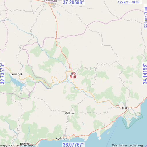
Mut GPS coordinates[2]
36° 38' 38.004" North, 33° 26' 19.86" East
| Map corner | latitude | longitude |
|---|---|---|
| Upper-left | 37.20598°, | 32.73573° |
| Center: | 36.64389°, | 33.43885° |
| Lower-right: | 36.07767°, | 34.14198° |
| Map W x H: | 125.5×125.5 km | = 78×78mi |
| max Lat: | 42.02683° ⇑95.9% North |
| Mut: | 36.64389° |
| min Lat: | ⇓4.1% South 35.9025° |
| min Long | Mut | max Long |
| 25.90902° | 33.43885° | 44.60099° |
| W 39.3%⇐ | ⇒60.7% E |
Elevation
Elevation of Mut is 311 m = 1020 ft, and this is 406.4 m = 1333 ft below average elevation for this country.
| Max E: |
2682 m = 8799 ft | 69.6% |
| Avg. | 717.4 m = 2354 ft | |
| Mut | 311 m = 1020 ft | |
Min E: |
0 m = 0 ft | 30.4% |
See also: Mut elevation on elevation.city.
Geographical zone
Mut is located in North temperate zone (between Tropic of Cancer and the Arctic Circle). Distance of this Northern Tropic circle is 1468.5 km =912.5 mi to South.| Distance of | km | miles | from Mut |
|---|---|---|---|
| North Pole | 5932.6 | 3686.3 | to North |
| Arctic Circle | 3326.8 | 2067.2 | to North |
| Tropic Cancer | 1468.5 | 912.5 | to South |
| Equator | 4074.4 | 2531.7 | to South |


Nearby cities:
15 places around Mut: (largest is in red/bold)
• Akdere
52.8 km =32.8 mi,  148°
148°
• Aydıncık
56.6 km =35.2 mi,  190°
190°
• Bucakkışla
50.7 km =31.5 mi,  312°
312°
• Ermenek
48.8 km =30.3 mi,  269°
269°
• Gülnar
33.8 km =21 mi, 186°
• Güzeloluk
59.8 km =37.2 mi,  73°
73°
• Karaman
63 km =39.1 mi,  341°
341°
• Kazancı
53.9 km =33.5 mi,  252°
252°
• Kırobası
39.2 km =24.4 mi,  77°
77°
• Ovacık
53.6 km =33.3 mi,  168°
168°
• Sarıkavak
19.5 km =12.1 mi,  110°
110°
• Silifke
53.3 km =33.1 mi,  123°
123°
• Taşucu
53.4 km =33.2 mi,  132°
132°
• Tepebaşı
64 km =39.8 mi, 272°
• Yeşildere
57.4 km =35.7 mi,  6°
6°
Sources, notices
• [Note1] Compared only with cities in Turkey existing in our database
• [Src1] Map data: © OpenStreetMap contributors (CC-BY-SA)
• [Src2] Other city data from geonames.org with taken over terms of usage.
• [Src3] Geographical zone / Annual Mean Temperature by Robert A. Rohde @ Wikipedia
