Tekirova geodata
Tekirova (Antalya) is a populated place; located in Turkey in Europe/Istanbul (GMT+3) time zone. With population of 20,000 people, there are 332 cities with bigger population in this country. Compared to other cities in Turkey, 96.9% of cities are located further ↑North; 72.9% of cities are located further →East and 97.5% of cities have higher elevation than Tekirova. Note1


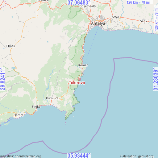
Tekirova GPS coordinates[2]
36° 30' 6.12" North, 30° 31' 38.028" East
| Map corner | latitude | longitude |
|---|---|---|
| Upper-left | 37.06483°, | 29.82411° |
| Center: | 36.5017°, | 30.52723° |
| Lower-right: | 35.93444°, | 31.23036° |
| Map W x H: | 125.7×125.7 km | = 78.1×78.1mi |
| max Lat: | 42.02683° ⇑96.9% North |
| Tekirova: | 36.5017° |
| min Lat: | ⇓3.1% South 35.9025° |
| min Long | Tekirova | max Long |
| 25.90902° | 30.52723° | 44.60099° |
| W 27.1%⇐ | ⇒72.9% E |
Elevation
Elevation of Tekirova is 11 m = 36 ft, and this is 706.4 m = 2318 ft below average elevation for this country.
| Max E: |
2682 m = 8799 ft | 97.5% |
| Avg. | 717.4 m = 2354 ft | |
| Tekirova | 11 m = 36 ft | |
Min E: |
0 m = 0 ft | 2.5% |
See also: Turkey elevation on elevation.city.
Geographical zone
Tekirova is located in North temperate zone (between Tropic of Cancer and the Arctic Circle). Distance of this Northern Tropic circle is 1452.7 km =902.7 mi to South.| Distance of | km | miles | from Tekirova |
|---|---|---|---|
| North Pole | 5948.5 | 3696.2 | to North |
| Arctic Circle | 3342.6 | 2077 | to North |
| Tropic Cancer | 1452.7 | 902.7 | to South |
| Equator | 4058.6 | 2521.9 | to South |


Nearby cities:
15 places around Tekirova: (largest is in red/bold)
• Altınyaka
17.2 km =10.7 mi,  291°
291°
• Antalya
47.6 km =29.6 mi,  18°
18°
• Beykonak
28 km =17.4 mi,  225°
225°
• Demre
56.3 km =35 mi,  239°
239°
• Finike
41.5 km =25.8 mi, 236°
• Geyikbayırı
42 km =26.1 mi,  351°
351°
• Gölova
54.7 km =34 mi,  307°
307°
• Göynük
17.7 km =11 mi,  6°
6°
• Kemer
11.1 km =6.9 mi, 15°
• Kepez
48.8 km =30.3 mi, 19°
• Konyaaltı
41.6 km =25.8 mi, 12°
• Kumluca
26 km =16.2 mi, 235°
• Muratpaşa
48.3 km =30 mi,  26°
26°
• Turunçova
37.9 km =23.5 mi,  247°
247°
• Çakırlar
41.2 km =25.6 mi,  4°
4°
Sources, notices
• [Note1] Compared only with cities in Turkey existing in our database
• [Src1] Map data: © OpenStreetMap contributors (CC-BY-SA)
• [Src2] Other city data from geonames.org with taken over terms of usage.
• [Src3] Geographical zone / Annual Mean Temperature by Robert A. Rohde @ Wikipedia
