Dargeçit geodata
Dargeçit (Mardin) is a seat of a second-order administrative division; located in Turkey in Europe/Istanbul (GMT+3) time zone. With population of 20,793 people, there are 323 cities with bigger population in this country. Compared to other cities in Turkey, 73.7% of cities are located further ↑North; 87.8% of cities are located further ←West and 61.2% of cities have lower elevation than Dargeçit. Note1


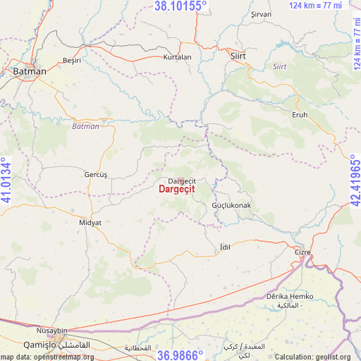
Dargeçit GPS coordinates[2]
37° 32' 46.176" North, 41° 42' 59.472" East
| Map corner | latitude | longitude |
|---|---|---|
| Upper-left | 38.10155°, | 41.0134° |
| Center: | 37.54616°, | 41.71652° |
| Lower-right: | 36.9866°, | 42.41965° |
| Map W x H: | 124×124 km | = 77.1×77.1mi |
| max Lat: | 42.02683° ⇑73.7% North |
| Dargeçit: | 37.54616° |
| min Lat: | ⇓26.3% South 35.9025° |
| min Long | Dargeçit | max Long |
| 25.90902° | 41.71652° | 44.60099° |
| W 87.8%⇐ | ⇒12.2% E |
Elevation
Elevation of Dargeçit is 899 m = 2949 ft, and this is 181.6 m = 596 ft above average elevation for this country.
| Max E: |
2682 m = 8799 ft | 38.8% |
| Dargeçit | 899 m 2949 ft | |
| Avg. | 717.4 m = 2354 ft | |
Min E: |
0 m = 0 ft | 61.2% |
See also: Turkey elevation on elevation.city.
Geographical zone
Dargeçit is located in North temperate zone (between Tropic of Cancer and the Arctic Circle). Distance of this Northern Tropic circle is 1568.8 km =974.8 mi to South.| Distance of | km | miles | from Dargeçit |
|---|---|---|---|
| North Pole | 5832.3 | 3624 | to North |
| Arctic Circle | 3226.4 | 2004.8 | to North |
| Tropic Cancer | 1568.8 | 974.8 | to South |
| Equator | 4174.7 | 2594 | to South |


Nearby cities:
15 places around Dargeçit: (largest is in red/bold)
• Baraniferho
18.8 km =11.7 mi,  117°
117°
• Başyurt
14.6 km =9.1 mi,  206°
206°
• Boyuncuk
21.6 km =13.4 mi,  128°
128°
• Dumanlı
20 km =12.4 mi,  186°
186°
• Fındık
22.1 km =13.7 mi,  99°
99°
• Gökçepınar
17.9 km =11.1 mi,  285°
285°
• Gülveren
20.7 km =12.9 mi,  251°
251°
• Karabayır
9.1 km =5.7 mi,  77°
77°
• Koçtepe
13.2 km =8.2 mi,  91°
91°
• Kılavuz
9.5 km =5.9 mi,  141°
141°
• Ortaca
16.3 km =10.1 mi,  240°
240°
• Suçatı
6.5 km =4 mi,  44°
44°
• Temelli
11.8 km =7.3 mi,  73°
73°
• Yarbaşı
21.6 km =13.4 mi, 142°
• Çukuryurt
21.1 km =13.1 mi,  283°
283°
Sources, notices
• [Note1] Compared only with cities in Turkey existing in our database
• [Src1] Map data: © OpenStreetMap contributors (CC-BY-SA)
• [Src2] Other city data from geonames.org with taken over terms of usage.
• [Src3] Geographical zone / Annual Mean Temperature by Robert A. Rohde @ Wikipedia
