Lodi geodata
Lodi (Siirt) is a seat of a third-order administrative division; located in Turkey in Europe/Istanbul (GMT+3) time zone. With population of 1,130 people, there are 1061 cities with bigger population in this country. Compared to other cities in Turkey, 70.2% of cities are located further ↑North; 89.6% of cities are located further ←West and 66% of cities have lower elevation than Lodi. Note1


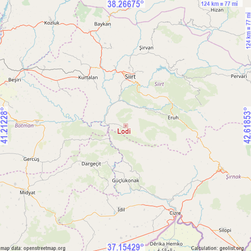
Lodi GPS coordinates[2]
37° 42' 45.396" North, 41° 54' 55.44" East
| Map corner | latitude | longitude |
|---|---|---|
| Upper-left | 38.26675°, | 41.21228° |
| Center: | 37.71261°, | 41.9154° |
| Lower-right: | 37.15429°, | 42.61853° |
| Map W x H: | 123.7×123.7 km | = 76.9×76.9mi |
| max Lat: | 42.02683° ⇑70.2% North |
| Lodi: | 37.71261° |
| min Lat: | ⇓29.8% South 35.9025° |
| min Long | Lodi | max Long |
| 25.90902° | 41.9154° | 44.60099° |
| W 89.6%⇐ | ⇒10.4% E |
Elevation
Elevation of Lodi is 976 m = 3202 ft, and this is 258.6 m = 848 ft above average elevation for this country.
| Max E: |
2682 m = 8799 ft | 34% |
| Lodi | 976 m 3202 ft | |
| Avg. | 717.4 m = 2354 ft | |
Min E: |
0 m = 0 ft | 66% |
See also: Turkey elevation on elevation.city.
Geographical zone
Lodi is located in North temperate zone (between Tropic of Cancer and the Arctic Circle). Distance of this Northern Tropic circle is 1587.3 km =986.3 mi to South.| Distance of | km | miles | from Lodi |
|---|---|---|---|
| North Pole | 5813.8 | 3612.5 | to North |
| Arctic Circle | 3207.9 | 1993.3 | to North |
| Tropic Cancer | 1587.3 | 986.3 | to South |
| Equator | 4193.2 | 2605.5 | to South |


Nearby cities:
15 places around Lodi: (largest is in red/bold)
• Bağlıca
22.7 km =14.1 mi,  320°
320°
• Civankan
21.5 km =13.4 mi,  351°
351°
• Dargeçit
25.5 km =15.8 mi,  223°
223°
• Dikboğaz
17 km =10.6 mi,  96°
96°
• Erenkaya
15.6 km =9.7 mi,  123°
123°
• Eruh
23 km =14.3 mi,  81°
81°
• Fındık
22.6 km =14 mi,  169°
169°
• Gölgelikonak
19.7 km =12.2 mi,  71°
71°
• Karabayır
18.6 km =11.6 mi,  207°
207°
• Koçtepe
19.3 km =12 mi,  192°
192°
• Serhatta
20.6 km =12.8 mi,  105°
105°
• Siirt
24.2 km =15 mi,  5°
5°
• Suçatı
18.9 km =11.7 mi, 223°
• Temelli
16.4 km =10.2 mi,  201°
201°
• Yelkesen
8.4 km =5.2 mi,  136°
136°
Sources, notices
• [Note1] Compared only with cities in Turkey existing in our database
• [Src1] Map data: © OpenStreetMap contributors (CC-BY-SA)
• [Src2] Other city data from geonames.org with taken over terms of usage.
• [Src3] Geographical zone / Annual Mean Temperature by Robert A. Rohde @ Wikipedia
