Karadirek geodata
Karadirek (Afyonkarahisar) is a seat of a third-order administrative division; located in Turkey in Europe/Istanbul (GMT+3) time zone. In our database, there are 1323 cities with bigger population. Compared to other cities in Turkey, 52.1% of cities are located further ↑North; 74.9% of cities are located further →East and 68.6% of cities have lower elevation than Karadirek. Note1


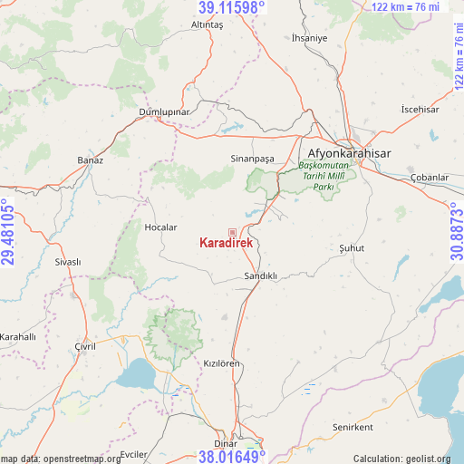
Karadirek GPS coordinates[2]
38° 34' 6.024" North, 30° 11' 3.012" East
| Map corner | latitude | longitude |
|---|---|---|
| Upper-left | 39.11598°, | 29.48105° |
| Center: | 38.56834°, | 30.18417° |
| Lower-right: | 38.01649°, | 30.8873° |
| Map W x H: | 122.3×122.3 km | = 76×76mi |
| max Lat: | 42.02683° ⇑52.1% North |
| Karadirek: | 38.56834° |
| min Lat: | ⇓47.9% South 35.9025° |
| min Long | Karadirek | max Long |
| 25.90902° | 30.18417° | 44.60099° |
| W 25.1%⇐ | ⇒74.9% E |
Elevation
Elevation of Karadirek is 1009 m = 3310 ft, and this is 291.6 m = 957 ft above average elevation for this country.
| Max E: |
2682 m = 8799 ft | 31.4% |
| Karadirek | 1009 m 3310 ft | |
| Avg. | 717.4 m = 2354 ft | |
Min E: |
0 m = 0 ft | 68.6% |
See also: Turkey elevation on elevation.city.
Geographical zone
Karadirek is located in North temperate zone (between Tropic of Cancer and the Arctic Circle). Distance of this Northern Tropic circle is 1682.5 km =1045.5 mi to South.| Distance of | km | miles | from Karadirek |
|---|---|---|---|
| North Pole | 5718.7 | 3553.4 | to North |
| Arctic Circle | 3112.8 | 1934.2 | to North |
| Tropic Cancer | 1682.5 | 1045.5 | to South |
| Equator | 4288.4 | 2664.7 | to South |


Nearby cities:
15 places around Karadirek: (largest is in red/bold)
• Afyonkarahisar
37.6 km =23.4 mi,  56°
56°
• Banaz
42 km =26.1 mi,  296°
296°
• Dombay
46.1 km =28.6 mi,  177°
177°
• Dumlupınar
36.5 km =22.7 mi,  330°
330°
• Haydarlı
38.6 km =24 mi,  152°
152°
• Hocalar
18.9 km =11.7 mi,  273°
273°
• Homa
40.4 km =25.1 mi,  205°
205°
• Kızılcasöğüt
45.9 km =28.5 mi,  281°
281°
• Kızılören
34.6 km =21.5 mi, 184°
• Sandıklı
13.7 km =8.5 mi, 147°
• Selçikler
46.7 km =29 mi,  260°
260°
• Sinanpaşa
20.2 km =12.6 mi,  14°
14°
• Sivaslı
44.2 km =27.5 mi, 260°
• İshaklı
43.6 km =27.1 mi,  199°
199°
• Şuhut
31.7 km =19.7 mi,  97°
97°
Sources, notices
• [Note1] Compared only with cities in Turkey existing in our database
• [Src1] Map data: © OpenStreetMap contributors (CC-BY-SA)
• [Src2] Other city data from geonames.org with taken over terms of usage.
• [Src3] Geographical zone / Annual Mean Temperature by Robert A. Rohde @ Wikipedia
