Sinanpaşa geodata
Sinanpaşa (Afyonkarahisar) is a seat of a second-order administrative division; located in Turkey in Europe/Istanbul (GMT+3) time zone. With population of 5,940 people, there are 660 cities with bigger population in this country. Compared to other cities in Turkey, 50.9% of cities are located further ↓South; 74.5% of cities are located further →East and 75.9% of cities have lower elevation than Sinanpaşa. Note1


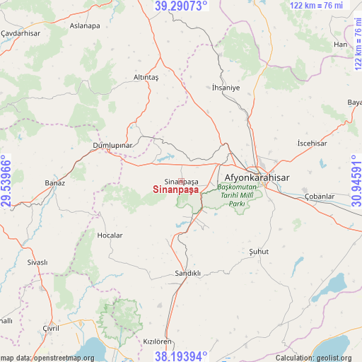
Sinanpaşa GPS coordinates[2]
38° 44' 39.984" North, 30° 14' 34.008" East
| Map corner | latitude | longitude |
|---|---|---|
| Upper-left | 39.29073°, | 29.53966° |
| Center: | 38.74444°, | 30.24278° |
| Lower-right: | 38.19394°, | 30.94591° |
| Map W x H: | 122×122 km | = 75.8×75.8mi |
| max Lat: | 42.02683° ⇑49.1% North |
| Sinanpaşa: | 38.74444° |
| min Lat: | ⇓50.9% South 35.9025° |
| min Long | Sinanpaşa | max Long |
| 25.90902° | 30.24278° | 44.60099° |
| W 25.5%⇐ | ⇒74.5% E |
Elevation
Elevation of Sinanpaşa is 1121 m = 3678 ft, and this is 403.6 m = 1324 ft above average elevation for this country.
| Max E: |
2682 m = 8799 ft | 24.1% |
| Sinanpaşa | 1121 m 3678 ft | |
| Avg. | 717.4 m = 2354 ft | |
Min E: |
0 m = 0 ft | 75.9% |
See also: Turkey elevation on elevation.city.
Geographical zone
Sinanpaşa is located in North temperate zone (between Tropic of Cancer and the Arctic Circle). Distance of this Northern Tropic circle is 1702.1 km =1057.6 mi to South.| Distance of | km | miles | from Sinanpaşa |
|---|---|---|---|
| North Pole | 5699.1 | 3541.3 | to North |
| Arctic Circle | 3093.2 | 1922 | to North |
| Tropic Cancer | 1702.1 | 1057.6 | to South |
| Equator | 4308 | 2676.9 | to South |


Nearby cities:
15 places around Sinanpaşa: (largest is in red/bold)
• Afyonkarahisar
26.1 km =16.2 mi,  87°
87°
• Altıntaş
36.9 km =22.9 mi,  341°
341°
• Banaz
42.6 km =26.5 mi,  268°
268°
• Dumlupınar
26 km =16.2 mi,  297°
297°
• Haydarlı
55.3 km =34.4 mi,  166°
166°
• Hocalar
30.2 km =18.8 mi,  232°
232°
• Işıklar
44 km =27.3 mi,  100°
100°
• Karadirek
20.2 km =12.6 mi,  194°
194°
• Kızılcasöğüt
51.1 km =31.8 mi,  258°
258°
• Kızılören
54.7 km =34 mi, 188°
• Sandıklı
31.2 km =19.4 mi,  175°
175°
• Çobanlar
47.1 km =29.3 mi, 95°
• İhsaniye
35 km =21.7 mi,  25°
25°
• İscehisar
45.9 km =28.5 mi,  73°
73°
• Şuhut
35.4 km =22 mi,  132°
132°
Sources, notices
• [Note1] Compared only with cities in Turkey existing in our database
• [Src1] Map data: © OpenStreetMap contributors (CC-BY-SA)
• [Src2] Other city data from geonames.org with taken over terms of usage.
• [Src3] Geographical zone / Annual Mean Temperature by Robert A. Rohde @ Wikipedia
