Dumlupınar geodata
Dumlupınar (Kütahya) is a seat of a second-order administrative division; located in Turkey in Europe/Istanbul (GMT+3) time zone. With population of 3,179 people, there are 849 cities with bigger population in this country. Compared to other cities in Turkey, 52.6% of cities are located further ↓South; 76% of cities are located further →East and 81.7% of cities have lower elevation than Dumlupınar. Note1


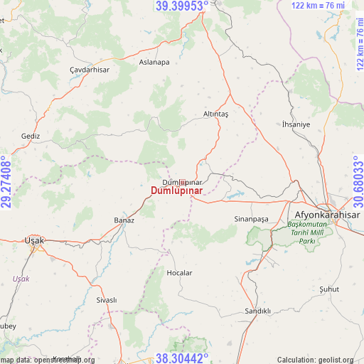
Dumlupınar GPS coordinates[2]
38° 51' 14.688" North, 29° 58' 37.92" East
| Map corner | latitude | longitude |
|---|---|---|
| Upper-left | 39.39953°, | 29.27408° |
| Center: | 38.85408°, | 29.9772° |
| Lower-right: | 38.30442°, | 30.68033° |
| Map W x H: | 121.8×121.8 km | = 75.7×75.7mi |
| max Lat: | 42.02683° ⇑47.4% North |
| Dumlupınar: | 38.85408° |
| min Lat: | ⇓52.6% South 35.9025° |
| min Long | Dumlupınar | max Long |
| 25.90902° | 29.9772° | 44.60099° |
| W 24%⇐ | ⇒76% E |
Elevation
Elevation of Dumlupınar is 1229 m = 4032 ft, and this is 511.6 m = 1678 ft above average elevation for this country.
| Max E: |
2682 m = 8799 ft | 18.3% |
| Dumlupınar | 1229 m 4032 ft | |
| Avg. | 717.4 m = 2354 ft | |
Min E: |
0 m = 0 ft | 81.7% |
See also: Turkey elevation on elevation.city.
Geographical zone
Dumlupınar is located in North temperate zone (between Tropic of Cancer and the Arctic Circle). Distance of this Northern Tropic circle is 1714.2 km =1065.2 mi to South.| Distance of | km | miles | from Dumlupınar |
|---|---|---|---|
| North Pole | 5686.9 | 3533.7 | to North |
| Arctic Circle | 3081 | 1914.4 | to North |
| Tropic Cancer | 1714.2 | 1065.2 | to South |
| Equator | 4320.2 | 2684.4 | to South |


Nearby cities:
15 places around Dumlupınar: (largest is in red/bold)
• Afyonkarahisar
50.2 km =31.2 mi,  102°
102°
• Altıntaş
25.6 km =15.9 mi,  26°
26°
• Aslanapa
41.3 km =25.7 mi,  347°
347°
• Banaz
23.5 km =14.6 mi,  236°
236°
• Gediz
53 km =32.9 mi,  287°
287°
• Hocalar
30.7 km =19.1 mi,  181°
181°
• Karadirek
36.5 km =22.7 mi,  150°
150°
• Kızılcasöğüt
35.2 km =21.9 mi,  230°
230°
• Sandıklı
50.2 km =31.2 mi, 149°
• Selçikler
48.4 km =30.1 mi,  215°
215°
• Sinanpaşa
26 km =16.2 mi,  117°
117°
• Sivaslı
47 km =29.2 mi,  212°
212°
• Uşak
53.5 km =33.2 mi,  247°
247°
• Çavdarhisar
48.8 km =30.3 mi,  320°
320°
• İhsaniye
42.7 km =26.5 mi,  62°
62°
Sources, notices
• [Note1] Compared only with cities in Turkey existing in our database
• [Src1] Map data: © OpenStreetMap contributors (CC-BY-SA)
• [Src2] Other city data from geonames.org with taken over terms of usage.
• [Src3] Geographical zone / Annual Mean Temperature by Robert A. Rohde @ Wikipedia
