Ağın geodata
Ağın (Elazığ) is a seat of a second-order administrative division; located in Turkey in Europe/Istanbul (GMT+3) time zone. With population of 4,014 people, there are 777 cities with bigger population in this country. Compared to other cities in Turkey, 53.6% of cities are located further ↓South; 65.2% of cities are located further ←West and 63.8% of cities have lower elevation than Ağın. Note1


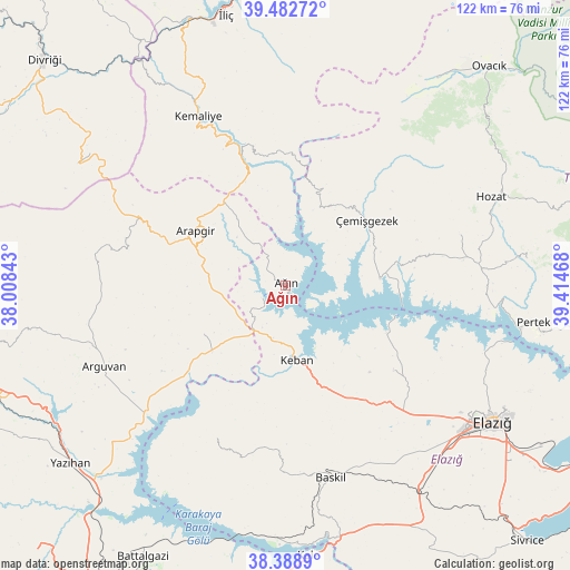
Ağın GPS coordinates[2]
38° 56' 16.512" North, 38° 42' 41.58" East
| Map corner | latitude | longitude |
|---|---|---|
| Upper-left | 39.48272°, | 38.00843° |
| Center: | 38.93792°, | 38.71155° |
| Lower-right: | 38.3889°, | 39.41468° |
| Map W x H: | 121.6×121.6 km | = 75.6×75.6mi |
| max Lat: | 42.02683° ⇑46.4% North |
| Ağın: | 38.93792° |
| min Lat: | ⇓53.6% South 35.9025° |
| min Long | Ağın | max Long |
| 25.90902° | 38.71155° | 44.60099° |
| W 65.2%⇐ | ⇒34.8% E |
Elevation
Elevation of Ağın is 944 m = 3097 ft, and this is 226.6 m = 743 ft above average elevation for this country.
| Max E: |
2682 m = 8799 ft | 36.2% |
| Ağın | 944 m 3097 ft | |
| Avg. | 717.4 m = 2354 ft | |
Min E: |
0 m = 0 ft | 63.8% |
See also: Turkey elevation on elevation.city.
Geographical zone
Ağın is located in North temperate zone (between Tropic of Cancer and the Arctic Circle). Distance of this Northern Tropic circle is 1723.6 km =1071 mi to South.| Distance of | km | miles | from Ağın |
|---|---|---|---|
| North Pole | 5677.6 | 3527.9 | to North |
| Arctic Circle | 3071.7 | 1908.7 | to North |
| Tropic Cancer | 1723.6 | 1071 | to South |
| Equator | 4329.5 | 2690.2 | to South |


Nearby cities:
15 places around Ağın: (largest is in red/bold)
• Akçapınar
20 km =12.4 mi,  87°
87°
• Arapgir
21.9 km =13.6 mi,  301°
301°
• Aydınlar
38.1 km =23.7 mi,  202°
202°
• Baskil
42.1 km =26.2 mi,  167°
167°
• Başpınar
28.1 km =17.5 mi,  355°
355°
• Dutluca
23.8 km =14.8 mi,  337°
337°
• Gedikler
17.9 km =11.1 mi,  26°
26°
• Hıdırbaba
29.8 km =18.5 mi,  129°
129°
• Keban
16.2 km =10.1 mi, 172°
• Kemaliye
40.6 km =25.2 mi,  332°
332°
• Poyraz
38.9 km =24.2 mi,  136°
136°
• Taşdelen
21.1 km =13.1 mi,  238°
238°
• Yoncalı
40.4 km =25.1 mi,  281°
281°
• Çağlarca
38.5 km =23.9 mi,  73°
73°
• Çemişgezek
21.4 km =13.3 mi,  52°
52°
Sources, notices
• [Note1] Compared only with cities in Turkey existing in our database
• [Src1] Map data: © OpenStreetMap contributors (CC-BY-SA)
• [Src2] Other city data from geonames.org with taken over terms of usage.
• [Src3] Geographical zone / Annual Mean Temperature by Robert A. Rohde @ Wikipedia
