Yoncalı geodata
Yoncalı (Malatya) is a seat of a third-order administrative division; located in Turkey in Europe/Istanbul (GMT+3) time zone. In our database, there are 1323 cities with bigger population. Compared to other cities in Turkey, 54.6% of cities are located further ↓South; 62.9% of cities are located further ←West and 85.8% of cities have lower elevation than Yoncalı. Note1


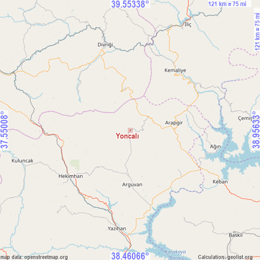
Yoncalı GPS coordinates[2]
39° 0' 32.868" North, 38° 15' 11.52" East
| Map corner | latitude | longitude |
|---|---|---|
| Upper-left | 39.55338°, | 37.55008° |
| Center: | 39.00913°, | 38.2532° |
| Lower-right: | 38.46066°, | 38.95633° |
| Map W x H: | 121.5×121.5 km | = 75.5×75.5mi |
| max Lat: | 42.02683° ⇑45.4% North |
| Yoncalı: | 39.00913° |
| min Lat: | ⇓54.6% South 35.9025° |
| min Long | Yoncalı | max Long |
| 25.90902° | 38.2532° | 44.60099° |
| W 62.9%⇐ | ⇒37.1% E |
Elevation
Elevation of Yoncalı is 1329 m = 4360 ft, and this is 611.6 m = 2007 ft above average elevation for this country.
| Max E: |
2682 m = 8799 ft | 14.2% |
| Yoncalı | 1329 m 4360 ft | |
| Avg. | 717.4 m = 2354 ft | |
Min E: |
0 m = 0 ft | 85.8% |
See also: Turkey elevation on elevation.city.
Geographical zone
Yoncalı is located in North temperate zone (between Tropic of Cancer and the Arctic Circle). Distance of this Northern Tropic circle is 1731.5 km =1075.9 mi to South.| Distance of | km | miles | from Yoncalı |
|---|---|---|---|
| North Pole | 5669.7 | 3523 | to North |
| Arctic Circle | 3063.8 | 1903.8 | to North |
| Tropic Cancer | 1731.5 | 1075.9 | to South |
| Equator | 4337.4 | 2695.1 | to South |


Nearby cities:
15 places around Yoncalı: (largest is in red/bold)
• Arapgir
21.2 km =13.2 mi,  80°
80°
• Arguvan
26.2 km =16.3 mi,  178°
178°
• Ağın
40.4 km =25.1 mi,  101°
101°
• Başpınar
42.5 km =26.4 mi,  61°
61°
• Danişment
18.7 km =11.6 mi,  345°
345°
• Divriği
42 km =26.1 mi,  343°
343°
• Dutluca
33.6 km =20.9 mi,  65°
65°
• Hasançelebi
32.8 km =20.4 mi,  258°
258°
• Hekimhan
35.3 km =21.9 mi,  232°
232°
• Kale
22 km =13.7 mi,  277°
277°
• Keban
48.1 km =29.9 mi,  119°
119°
• Kemaliye
35.2 km =21.9 mi,  36°
36°
• Mursal
31.1 km =19.3 mi,  304°
304°
• Taşdelen
28.9 km =18 mi,  131°
131°
• Yazıhan
46.8 km =29.1 mi,  188°
188°
Sources, notices
• [Note1] Compared only with cities in Turkey existing in our database
• [Src1] Map data: © OpenStreetMap contributors (CC-BY-SA)
• [Src2] Other city data from geonames.org with taken over terms of usage.
• [Src3] Geographical zone / Annual Mean Temperature by Robert A. Rohde @ Wikipedia
