Karayün geodata
Karayün (Sivas) is a seat of a third-order administrative division; located in Turkey in Europe/Istanbul (GMT+3) time zone. In our database, there are 1323 cities with bigger population. Compared to other cities in Turkey, 64% of cities are located further ↓South; 57.9% of cities are located further ←West and 89.4% of cities have lower elevation than Karayün. Note1


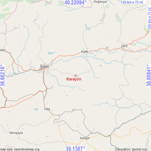
Karayün GPS coordinates[2]
39° 40' 54.984" North, 37° 18' 19.008" East
| Map corner | latitude | longitude |
|---|---|---|
| Upper-left | 40.22094°, | 36.60216° |
| Center: | 39.68194°, | 37.30528° |
| Lower-right: | 39.1387°, | 38.00841° |
| Map W x H: | 120.3×120.3 km | = 74.8×74.8mi |
| max Lat: | 42.02683° ⇑36% North |
| Karayün: | 39.68194° |
| min Lat: | ⇓64% South 35.9025° |
| min Long | Karayün | max Long |
| 25.90902° | 37.30528° | 44.60099° |
| W 57.9%⇐ | ⇒42.1% E |
Elevation
Elevation of Karayün is 1449 m = 4754 ft, and this is 731.6 m = 2400 ft above average elevation for this country.
| Max E: |
2682 m = 8799 ft | 10.6% |
| Karayün | 1449 m 4754 ft | |
| Avg. | 717.4 m = 2354 ft | |
Min E: |
0 m = 0 ft | 89.4% |
See also: Turkey elevation on elevation.city.
Geographical zone
Karayün is located in North temperate zone (between Tropic of Cancer and the Arctic Circle). Distance of this Northern Tropic circle is 1806.3 km =1122.4 mi to South.| Distance of | km | miles | from Karayün |
|---|---|---|---|
| North Pole | 5594.8 | 3476.4 | to North |
| Arctic Circle | 2989 | 1857.3 | to North |
| Tropic Cancer | 1806.3 | 1122.4 | to South |
| Equator | 4412.2 | 2741.6 | to South |


Nearby cities:
15 places around Karayün: (largest is in red/bold)
• Bedirli
59.7 km =37.1 mi,  259°
259°
• Beypınarı
39.6 km =24.6 mi,  119°
119°
• Bulucan
38.9 km =24.2 mi,  86°
86°
• Celâlli
10.2 km =6.3 mi,  83°
83°
• Deliktaş
38.8 km =24.1 mi,  192°
192°
• Direkli
56 km =34.8 mi,  273°
273°
• Hafik
20.6 km =12.8 mi,  19°
19°
• Kangal
50.4 km =31.3 mi,  171°
171°
• Kavak
45.9 km =28.5 mi,  160°
160°
• Kayadibi
55.5 km =34.5 mi,  246°
246°
• Sincan
53.8 km =33.4 mi, 115°
• Sivas
25.8 km =16 mi,  286°
286°
• Ulaş
34.9 km =21.7 mi,  220°
220°
• Zara
45.5 km =28.3 mi,  58°
58°
• Çetinkaya
54.2 km =33.7 mi,  149°
149°
Sources, notices
• [Note1] Compared only with cities in Turkey existing in our database
• [Src1] Map data: © OpenStreetMap contributors (CC-BY-SA)
• [Src2] Other city data from geonames.org with taken over terms of usage.
• [Src3] Geographical zone / Annual Mean Temperature by Robert A. Rohde @ Wikipedia
